skip to main content

Research

::: Home/Research - Research Fields

Research Fields

Seismology

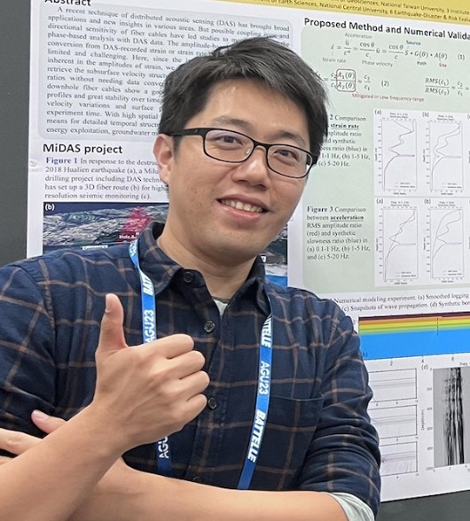
Research Fellows/Professors︰Bor-Shouh HuangKuo-Fong MaCheng-Horng LinBan-Yuan KuoShiann-Jong LeeWu-Cheng ChiWen-Che YuHsin-Hua Huang
Research Scientists︰Wen-Tzong LiangChing-Ren LinChin-Jen LinChin-Shang Ku

Seismology uses information that waves carry from earthquakes and various natural sources (e.g. ocean waves) to study the physical properties and structures of sources and subsurface medium. With that, we investigate their relationships to wide-spectrum topics of active faults, orogenic process, volcanic magmatic system, inner core evolution, etc. from shallow to deep Earth.

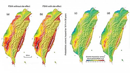
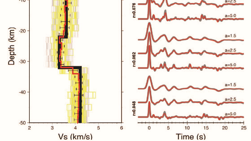
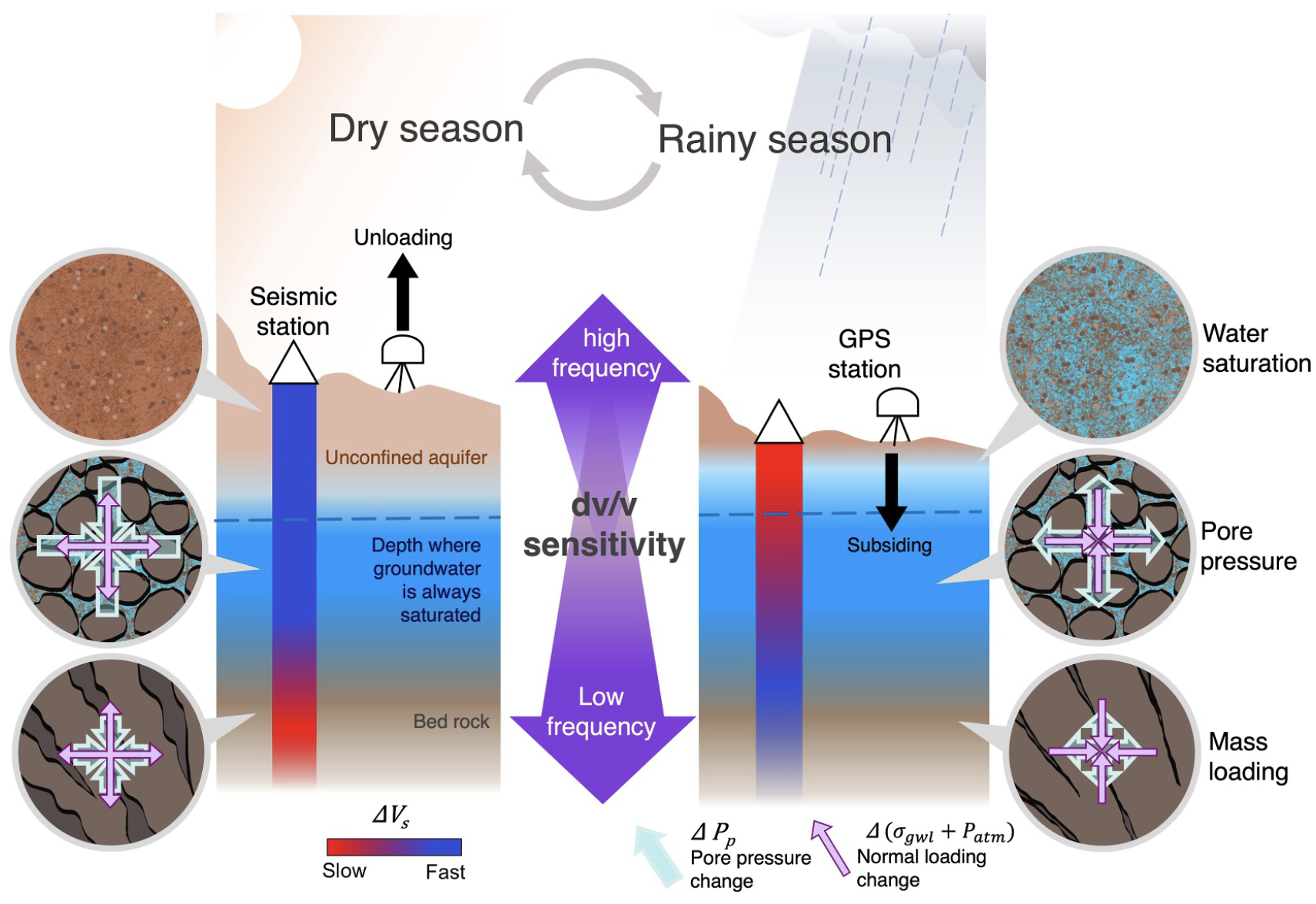
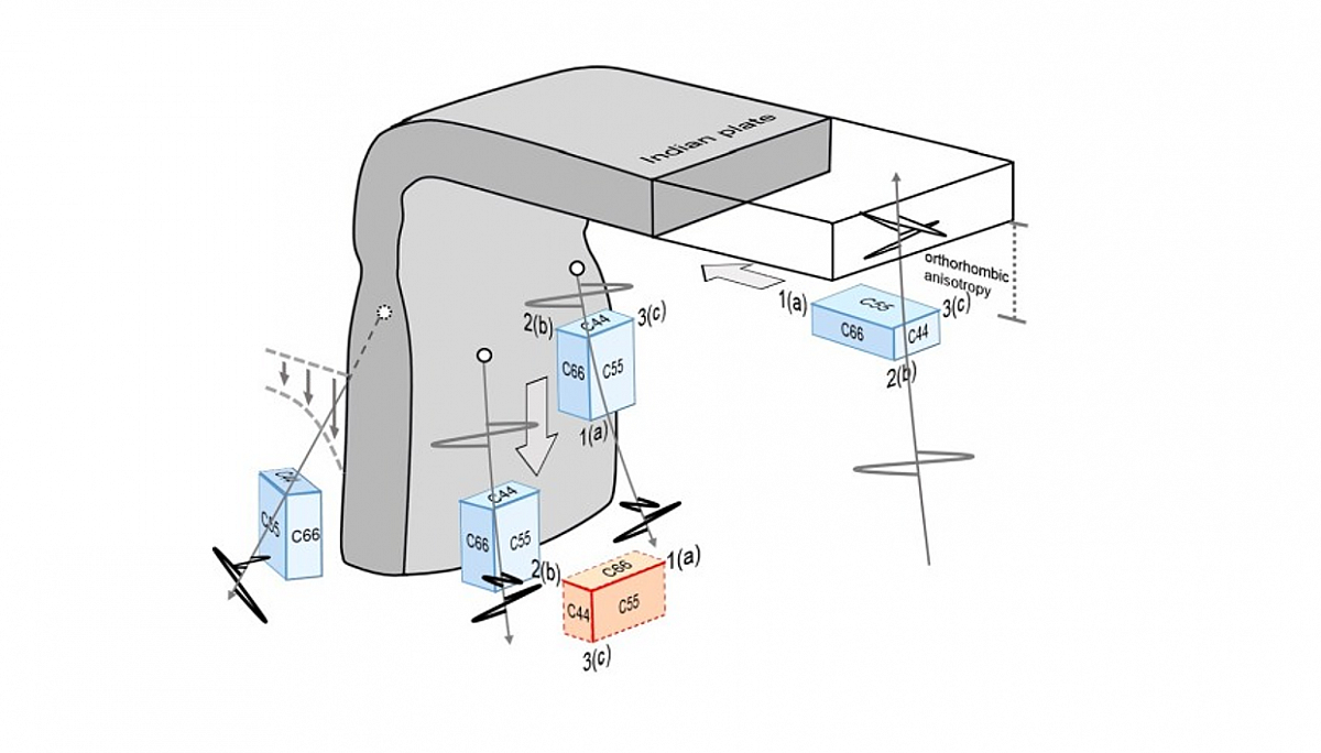
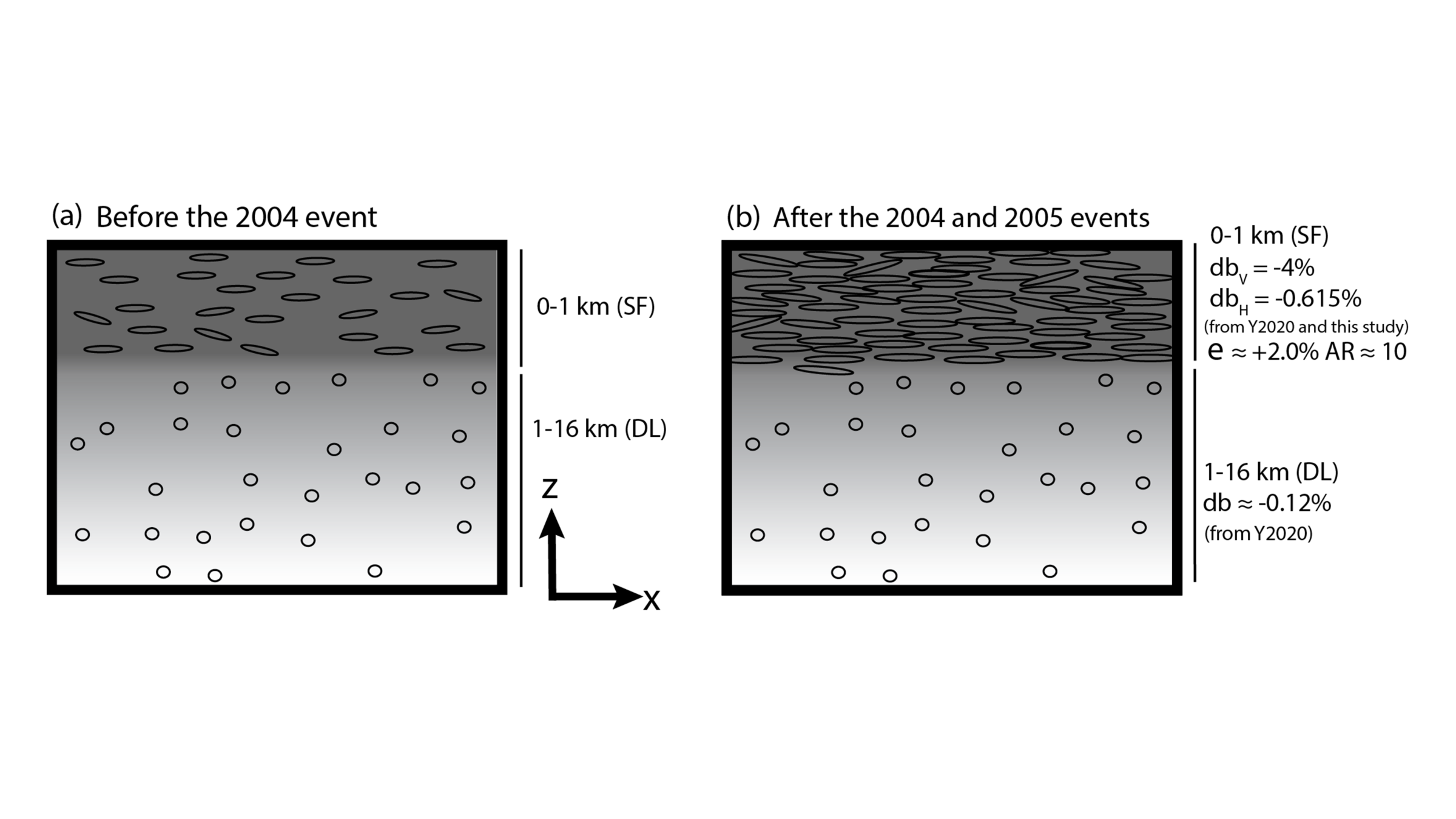
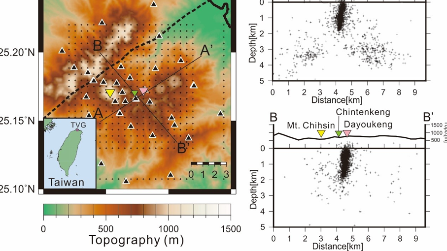
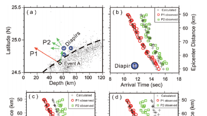
Recent focuses of IES seismology research include (1) Investigating the earthquake cycles and rupture mechanisms with numerical models, (2) Using high-resolution waveform simulation to study fault rupture processes, (3) Monitoring volcanoes and landslides with non-traditional seismological methods, (4) Using shear-wave splitting to illuminating the dynamics of subduction zones and mountain orogeny, (5) Extracting rotational ground motions from seismic array observations, (6) Strong ground motion prediction and warning for mediate-to-large magnitude earthquakes, (7) Resolving 3-Dstructure of subducting slabs and volcanic reservoirs with seismic imaging techniques, (8) Utilizing seismic reflection data to investigating the offshore sedimentary history and gas hydrate distribution, (9) Integrating multidisciplinary precursor observations for earthquake forecast.

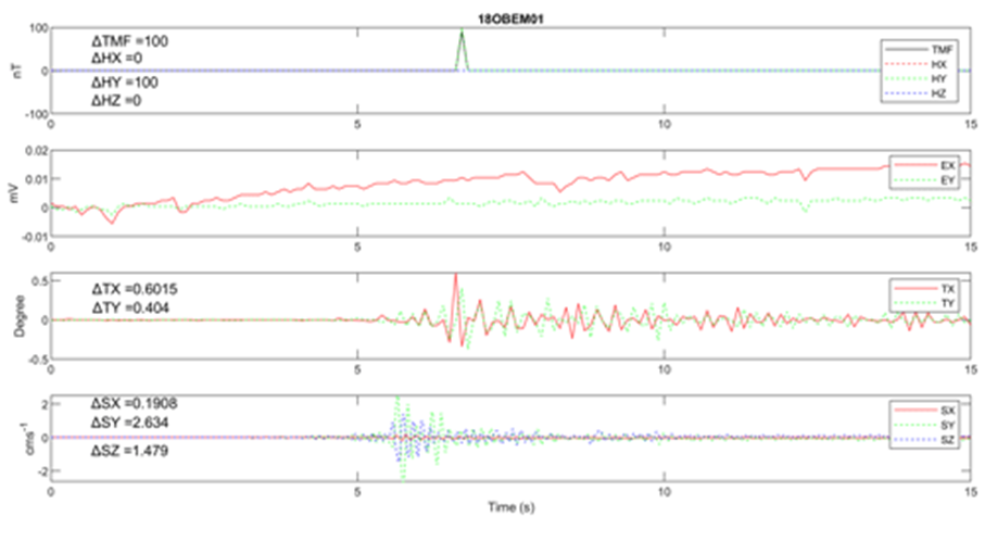
IES also deployed and is currently operating many unique seismic networks in Taiwan and abroad, including Broadband Array in Taiwan for Seismology (BATS), Taipei Basin Borehole Array, Taiwan Mountain Area Strong Motion Network, Tatun Volcano Seismic Network, and temporal networks in Southeast and Central Asia, receiving real-time waveform data via exchange and satellite from more than 1000 stations worldwide. For technical development, IES has pioneered the effort to design, build, and commercialize our own ocean-bottom seismometer with the Institute of Undersea Technology of National Sun Yat-sen University and the Taiwan Ocean Research Institute of National Applied Research Labs; and kept collaborating with LMU München and EOS at Nanyang Technological University for advancing new generation of rotational seismometer and infrasound sensor. Integrating the unique seismic networks and instruments, the IES seismology research aims to take an active role in understanding multiscale structural systems of Earth interior and to mitigating earthquake hazard and various geohazards in Taiwan and Southeast Asia.

Research Highlights

S Coda and Rayleigh Waves From a Decade of Repeating Earthquakes Reveal Discordant Temporal Velocity Changes Since the 2004 Sumatra Earthquake
Earthquake slip leads to stress relaxation in the crust, whereas healing of the damage induced by strong ground motion predominantly occurs in the near surface. Temporal changes in the seismic velocity structure after large earthquakes can be driven by diverse mechanisms, such as aseismic slip or fault zone healing, but the timescales governing these processes are very similar, making them difficult to distinguish. We detect temporal velocity changes in the crust since the great 2004 Sumatra and 2005 Nias earthquakes using the high‐frequency late‐arriving scattered waves after the S phase and long‐period Rayleigh waves of repeating earthquakes. We find that the temporal velocity changes in the scattered waves exhibit steady logarithmic recovery from 2005 to 2015, whereas the Rayleigh wave velocity recovery was interrupted by several large earthquakes after late 2007. The difference between these two temporal trends in velocity change is the key to distinguishing between a damage/healing/redamage cycle near the surface and slow deformation (e.g., afterslip and postseismic relaxation) at depth. Rayleigh waves are highly sensitive to the near‐surface damage and healing after the 2004/2005 events and also the repeated damage induced by the 2007 and 2008 earthquakes. Steady velocity recovery of the scattered waves primarily corresponds to slow deformation at depth.
Yu, Wen-che
More
Active Volcanism Revealed from a Seismicity Conduit in the Long-resting Tatun Volcano Group of Northern Taiwan
A dramatic improvement of the earthquake location model surprisingly show that, from 2014 to 2017, one major group of events (>1000) persistently clustered within a ~500 m diameter vertical conduit with a ~2 km height (Figure below). The seismic zone is probably triggered by the significantly volcanic gases and fluids ascending from the deep magma reservoir. Combined with a variety of results from literature, the seismicity conduit near the strong fumarole is the evidence for an active volcano and also identifies a likely pathway for ascending magma if the TVG erupts again in the future. But possibility of developing different magma pathways at other clustered seismic zones such as beneath Mt. Chihsin may not be totally excluded. The detailed results were published at Scientific Reports (Pu et al., 2020).
Lin, Cheng-Horng 
More
Frequency-Dependent Seismic Velocity Variations Reveal Layered Aquifer Behavior Under Groundwater Fluctuations
Frequency-dependent seismic velocity variations (dv/v) provide depth-resolved constraints on aquifer behavior under groundwater fluctuations. We analyze 17 years of dv/v time series from ambient noise interferometry in the Chiang Mai Basin, Thailand, and observe contrasting dv/v behavior below and above 1 Hz. By integrating GPS, meteorological, and GWL data with poroelastic stress modeling, we disentangle the contemporaneous effects of pore saturation, pore pressure change, and mass loading. Our results show that the pore saturation and pore pressure change jointly influence shallow aquifer layers, while mass loading governs deeper responses. This depth-dependent interplay highlights the importance of effective stress modeling in interpreting dv/v patterns and the potential of passive seismic techniques to monitor layered hydromechanical processes in aquifer systems.
Huang, Hsin-Hua
More
Mantle flow entrained by the Hindu Kush continental subduction inferred from source-side seismic anisotropy
The intermediate-depth seismicity below the Hindu-Kush orogen is thought to mark the Indian-plate subduction with the bottom half of the slab currently breaking off. Unique features of this continental subduction are the near-vertical slab and the roughly stationary convergence boundary. How this subduction affects the mantle flow patterns remains to be understood. In this study we measured source-side shear wave splitting on the S waves from Hindu Kush intraslab events to sample the surrounding mantle. The observed fast polarization directions exhibit a circular pattern around the slab resembling that predicted for the toroidal flow driven by slab rollback. However, the rollback scenario is not favored because it hardly sustains in dynamic models without a considerable retreat of convergence boundary. We propose that the observed pattern is produced by the sub-vertical shear flow entrained by the steep descent of the slab and the ongoing breakoff. This scenario requires the existence of A-type or AG-type olivine fabrics with strong orthorhombic anisotropy in mid- to lower upper mantle, which is consistent with the global models of azimuthal and radial anisotropy. This interpretation circumvents the debate on the cause of trench-parallel anisotropy in some oceanic subduction zones where slab entrainment and rollback may coexist, and supports the notion that orthorhombic anisotropy of olivine may play an important role in shaping mantle anisotropy.
Kuo, Ban-Yuan
More
Evaluations of an ocean bottom electro-magnetometer and preliminary results offshore NE Taiwan
The first stage of field experiments involving the design and construction of a low-power consumption ocean bottom electro-magnetometer (OBEM) has been completed, which can be deployed for more than 180 d on the seafloor with a time drift of less than 0.95 ppm. To improve the performance of the OBEM, we rigorously evaluated each of its units, e.g., the data loggers, acoustic parts, internal wirings, and magnetic and electric sensors, to eliminate unwanted events such as unrecovered or incomplete data. The first offshore deployment of the OBEM together with ocean bottom seismographs (OBSs) was performed in NE Taiwan, where the water depth is approximately 1400 m. The total intensity of the magnetic field (TMF) measured by the OBEM varied in the range of 44 100–44 150 nT, which corresponded to the proton magnetometer measurements. The daily variations in the magnetic field were recorded using the two horizontal components of the OBEM magnetic sensor. We found that the inclinations and magnetic data of the OBEM varied with two observed earthquakes when compared to the OBS data. The potential fields of the OBEM were slightly, but not obviously, affected by the earthquakes.
Lin, Ching-Ren
More
An ML-Enhanced Earthquake Catalog for the 2024 MW 7.4 Hualien Earthquake Sequence: Insights Into Structural Transition From Collision to Subduction in Eastern Taiwan
A devastating MW 7.4 earthquake struck the northern Longitudinal Valley in eastern Taiwan on 3 April 2024. The intense and prolonged aftershock sequence over the following month exposed both the region's tectonic complexity and the challenge of timely earthquake cataloging. Gaps in the initial catalog from the local agency revealed short-term incompleteness, potentially delaying critical hazard assessments and emphasizing the need for more efficient data-processing workflows. To address this issue, we developed an automated workflow, AutoQuake, which processes continuous waveform data using machine learning (ML) models and seismological algorithms. AutoQuake integrates phase picking, phase association, 3-D double-difference relocation, local magnitude estimation, and focal mechanism determination within a flexible Python interface that allows user customization. The resulting ML-enhanced event and focal mechanism catalogs are five times larger than the local agency catalog and 10 times larger than the moment tensor inversion catalogs. The 2024 Hualien earthquake sequence revealed by AutoQuake complements the 2018–2021 seismicity in spatial distribution and resolves detailed fault interactions between the Central Range Fault (CRF) and the Longitudinal Valley Fault (LVF) systems, including a newly-developed deep west-dipping fault and an east-dipping fault parallel to the LVF. These features suggest an evolving system of conjugate faulting that accommodates the high convergence rate along the plate boundary (∼30–40 mm/yr). This study demonstrates the potential of ML-based workflows to efficiently process large volumes of seismic data, enabling timely responses to major earthquake sequences and offering new insights into the complex seismogenic structures in the tectonic transition from collision to subduction.
Huang, Hsin-Hua
More
Mantle wedge diapirs detected by a dense seismic array in Northern Taiwan
It is conventionally believed that magma generation beneath the volcanic arc is triggered by the infiltration of fluids or melts derived from the subducted slab. However, recently geochemical analyses argue the arc magma may be formed by mélange diapirs that are physically mixed by sediment, altered oceanic crust, fluids, and mantle above the subducted slab. Further numerical modeling predicts that the mantle wedge diapirs have significant seismic velocity anomalies, even though these have not been observed yet. Here we show that unambiguously later P-waves scattered from some obstacles in the mantle wedge are well recorded at a dense seismic array (Formosa Array) in northern Taiwan. It is the first detection of seismic scattering obstacles in the mantle wedge. Although the exact shape and size of the scattered obstacles are not well constrained by the arrival-times of the later P-waves, the first order approximation of several spheres with radius of ~ 1 km provides a plausible interpretation. Since these obstacles were located just beneath the magma reservoirs around depths between 60 and 95 km, we conclude they may be mantle wedge diapirs that are likely associated with magma generation beneath active volcanoes.
Lin, Cheng-Horng 
More
Complex Triggering Supershear Rupture of the 2018 Mw 7.5 Palu, Indonesia, Earthquake Determined from Teleseismic Source Inversion
An MwMw 7.5 earthquake struck Palu in the northern coast of Sulawesi island, Indonesia, on 28 September 2018. Its focal mechanism was determined to be a left‐lateral strike‐slip fault, which is generally expected to not produce a tsunami. However, a large tsunami with runup heights of more than 6 m was observed along the coast of Palu city. Here, we show a complex triggering supershear source model as determined by teleseismic waveform inversion. Three asperities with different slip characteristics were found on the 120‐kilometer‐long rupture zone. Significant triggering rupture with a supershear speed was observed south of the epicenter, which was just beneath Palu city. This special rupture process can cause a strong directivity effect that produced anomalously large ground shaking with nonlinear effects in Palu area. The coseismic deformation determined from the inverted source model showed large horizontal displacements. These horizontal movements combined with complex bathymetry and topography could have pushed seawater to generate a tsunami even though the Palu earthquake was a strike‐slip event.
Lee, Shiann-Jong
More
Deep-sea turbulence evolution observed by multiple closely spaced instruments
Turbulent mixing in the deep ocean is not well understood. The breaking of internal waves on sloped seafloor topography can generate deep-sea turbulence. However, it is difficult to measure turbulence comprehensively due to its multi-scale processes, in addition to flow–flow and flow–topography interactions. Dense, high-resolution spatiotemporal coverage of observations may help shed light on turbulence evolution. Here, we present turbulence observations from four broadband ocean bottom seismometers (OBSs) and a 200-m vertical thermistor string (T-string) in a footprint of 1 × 1 km to characterize turbulence induced by internal waves at a depth of 3000 m on a Pacific continental slope. Correlating the OBS-calculated time derivative of kinetic energy and the T-string-calculated turbulent kinetic energy dissipation rate, we propose that the OBS-detected signals were induced by near-seafloor turbulence. Strong disturbances were detected during a typhoon period, suggesting large-scale inertial waves breaking with upslope transport speeds of 0.2–0.5 m s−1. Disturbances were mostly excited on the downslope side of the array where the internal waves from the Pacific Ocean broke initially and the turbulence oscillated between < 1 km small-scale ridges. Such small-scale topography caused varying turbulence-induced signals due to localized waves breaking. Arrayed OBSs can provide complementary observations to characterize deep-sea turbulence.
Chi, Wu-Cheng
More
Deep crust analysis beneath northern Vietnam by using receiver functions: Implications for SE Asia continental extrusion
The shear-wave velocity structures of the crust and uppermost mantle of northern Vietnam were analyzed using the receiver function (RF) method at 25 broadband stations to investigate the regional crustal structure and its tectonic evolution. In this study, we presented a new crustal shear-wave velocity structure of northern Vietnam determined through RF analysis. Our results revealed significant variations in crustal thickness and deep crustal velocities across the study area. Along the Red River shear zone (RRSZ), the patterns of the crustal structure were distinct on both sides; they were simple and complex, respectively, in the blocks on northeast and southwest. A low-velocity zone (LVZ) was widely observed in the northwestern corner of the study area, and significant lateral variations in the thickness and strength of the crustal structure were observed from north to south. This LVZ was distributed as a thick and deep zone in the north and became thinner and shallower in the central region; the LVZ finally disappeared in the south. Two end members of the origin of the LVZ were proposed. The LVZ can be considered a weak crustal layer that escaped from the southeastern margin of the Tibetan Plateau, or it may have been formed from a paleo-subducted slab beneath it because of an onsite mantle heat source. The existence of this LVZ suggests that the movement of the RRSZ is possibly concentrated above the LVZ and that extension to the upper mantle is not necessary in the present stage. The above tectonic regime supports the possibility that the RRSZ is a strikeslip fault with a feature restricted in the crust.Full Article: https://doi.org/10.3319/Tao.2020.03.05.01 
Huang, Bor-Shouh
More
Crowdsourcing Platform Toward Seismic Disaster Reduction: The Taiwan Scientific Earthquake Reporting (TSER) System
We initiated an earthquake reporting project in 2016 to collect field observations of ground damages caused by large earthquakes from trained volunteers and interested citizens. After a potentially damaging earthquake occurs in the Taiwan area, our system, the Taiwan scientific earthquake reporting system (TSER), would send a notice to the participants, who are encouraged to visit the epicentral area to survey and describe in as much detail as possible the variations of the ground damages using a Usahidi-based mapping platform. They may also upload relevant images in the field when the condition permitted (i.e., good mobile signal). This collective information will be shared with the public after a quick check by the on-duty scientists. Statistically, in Taiwan damaging inland earthquakes, e.g., magnitude greater than 6, occurred every 2–3 years. During the intermittent time, the platform serves to share educational materials such as pictures of geological structures and landscapes, which are beneficial to many of the volunteers, who are high school science teachers. This experimental, science-oriented crowdsourcing system was first tested during the February 6, 2018 Mw 6.4 offshore Hualien, Taiwan earthquake. We received 19 field reports in the first 3 days after the earthquake. Most of these reports provided surface damage details along the Milun fault, which also ruptured during the 1951 ML 7.1 Longitudinal Valley earthquake sequence. The crowdsourcing approach of TSER has proven to be effective in enhancing public awareness and the potential for scientific advancement in hazard mitigation.
Liang, Wen-Tzong
More
Rayleigh-Love Discrepancy Highlights Temporal Changes in Near-Surface Radial Anisotropy After the 2004 Great Sumatra Earthquake
This study detects temporal changes in the wave speeds of long-period Rayleigh and Love waves after the 2004 Great Sumatra Earthquake, which were measured from repeating earthquakes. Seismic observations reveal that the Rayleigh-wave speed reduction is more than that of Love waves by a factor of six. Love waves are much more sensitive to the S-wave speed of the shallow crust than Rayleigh waves in isotropic media (i.e., the S-wave speed is the same in all directions). One would therefore anticipate considerable Love-wave speed reduction if the S-wave speed reduction results from the near surface after great earthquakes. However, the observations indicate the opposite. The result of waveform modeling suggests that these unexpected observations can be suitably explained by an increase in radial anisotropy as a result of increasing fluid-filled horizontal cracks after great earthquakes.
Yu, Wen-che
More
Probabilistic seismic hazard assessment for Taiwan: TEM PSHA2020
The Taiwan Earthquake Model (TEM) published the first version of the Taiwan probabilistic seismic hazard assessment (named TEM PSHA2015) 5 years ago.
Ma, Kuo-Fong
More
Spatiotemporal Monitoring of a Frequent-Slip Fault Zone Using Downhole Distributed Acoustic Sensing at the MiDAS Project
The occurrence of seismic or aseismic slips on a fault is mainly controlled by fault zone structures and properties. However, high-resolution in situ observations are challenging for active faults with uncertain locations or weathered outcrops. The Milun Fault, which repeatedly ruptured during the 1951 and 2018 Hualien earthquakes in Taiwan, offers a unique opportunity to investigate active fault zones using distributed acoustic sensing (DAS). DAS translates the phase shifts of scattering echoes in optical fibers into dynamic strain measurements, enabling continuous, high-resolution monitoring across fault zones. The Milun Fault Drilling and All-inclusive Sensing (MiDAS) project, initiated in late 2021, drilled two holes on either side of the fault and reached the fault zone at a depth of approximately 500 m in hanging wall. The high-density sampling of downhole fibers enables us to identify the 20-meter-thick Milun Fault zone and other hidden faults at various depths. An amplitude-based method that utilizes strain-rate data properties is proposed to map subsurface velocity structures over time, with the derived velocity profiles consistent with logging data. This method shows great potential for detailed temporal structural monitoring in broad applications such as energy exploitation, groundwater management, and geohazard monitoring.
Huang, Hsin-Hua
More