Seismic tomography and multi-dataset joint inversion
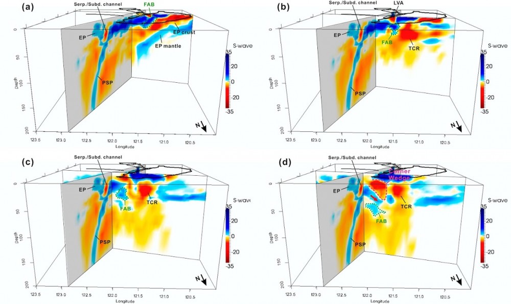
One of my main research focuses is on the tomographic joint inversion of multi-dataset to improving our knowledge of subsurface structures and related tectonics. The crustal P-wave and Pn wave data, for example, are usually analyzed separately for individual studies but they can be incorporated in a complementary sense. With the dataset from a newly deployed portable array in northern Vietnam, we employed both phases to obtain the first local seismic tomography for the Red River shear zone (RRSZ), and shows that the RRSZ could be a lithospheric structure at least cutting through the crust (Huang et al., 2013). Moreover, for Taiwan region we also developed an elaborating joint-inversion scheme for various datasets (P-, S-wave, S-P time data, and especially the borehole logging data for near-surface constraints) to derive Vp, Vs, and Vp/Vs models. These new set of models which have comparable resolution and internal consistency can facilitate the tectonic exploration, waveform simulation, etc. (Huang et al., 2014a). In order to expand the model resolution in depth, the teleseismic data is further measured and incorporated together to investigate the lithospheric structures and slab interaction in the upper mantle (Huang et al., 2014b).
Earthquake early warning and hazard mitigation
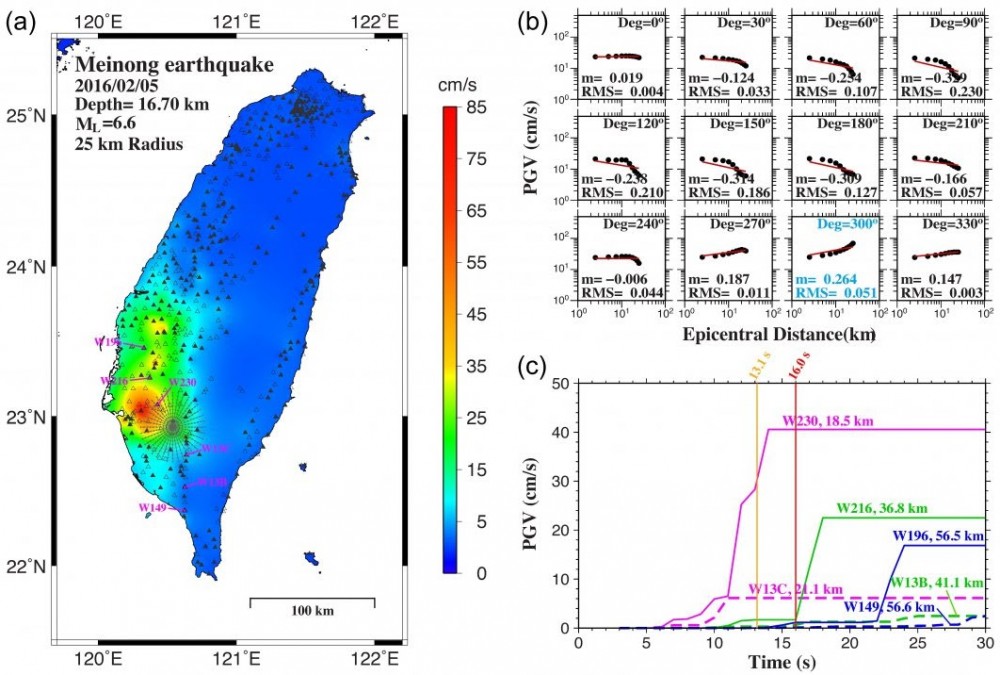
Earthquakes are one of the most frequent natural hazards in Taiwan. To mitigate the level of their damage, the development of early warning system is of great importance on one hand (Wu et al., 2011); gaining better understanding of ground motion relations, such as medium attenuation, source characteristics (e.g. directivity), and site effects, is also critical on the other hand. With derived high resolution velocity models, we have analyzed the source properties of Nantou (Lee et al., 2015) and Ruisui earthquakes (Lee et al., 2014) and demonstrated the capability of capturing realistic ground motions to some extent, especially across mountains and within basins, which could give us better insights into complicated wave propagation and help the hazard mitigation ultimately. More recently, using near-field ground motion data from a dense seismic network (P-alert), we showed that earthquake rupture directivity information could be estimated at a near-real-time basis and possibly help for more accurate shaking alerts in EEW systems (Jan et al., 2018).
Seismotectonics and regional tectonic reconstruction
I am interested in exploring and reconstructing the regional tectonics in various aspects. Conducted issues, for instance, include constructing the structural kinematic model of northeastern Taiwan by spatial analyses of seismicity and stress (Huang et al., 2012), delineating the complex Moho geometry in Taiwan arc-continent collision system using Genetic-algorithm 1D velocity inversion and local tomography mapping technique (Ustaszewski et al., 2012), and proposing an ongoing tectonic erosion process of forearc basement beneath the southernmost Longitudinal Valley, based on local tomographic images and two earthquake sequences in the eastern Taiwan (Shyu et al., 2011).
Unusual earthquake sequence analysis and its tectonic implications
This topic aims at investigating some out-of-the-ordinary earthquakes against the background tectonics. For example, in the case of a large inland earthquake, 4 March 2010 MW 6.3 Jiasian, Taiwan earthquake, occurring in a seismic gap, we integrated the strong motion data to better relocate the earthquake sequence, determined the focal mechanisms, and discussed their implications to tectonics and hazard mitigation for southern Taiwan(Huang et al., 2011). Two years later, the ML 6.4 Wutai, Taiwan earthquake occurred nearby and a bit deeper. Using a P-wave polarity fitting method, we also reexamined its source parameters for tectonic discussion (Chen et al., 2013).
Body-wave seismic interferometry
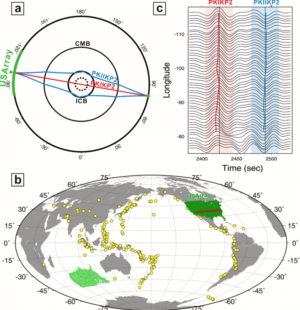
Recent success of body wave retrieval from noise or coda correlations that creates new 3-D paths other than laterally propagating surface waves has advanced our ability of probing and monitoring deep Earth. Growing applications have been made for imaging Moho and transition zone discontinuities, D” reflector, inner core structure, and potentially monitoring volcanic system at depth, showing great promise to complement earthquake-based data. Applying earthquake coda interferometry techniques to 1846 USArray stations deployed across North America from January 2004 through September 2013, we show that the spatial analysis of the differential travel time residuals between two core phases, PKIKP2 and PKIIKP2, reveals significant short-wavelength variation and implies the existence of strong structural variability in the deep Earth. Especially, a linear N-S trending anomaly across the middle of the U.S. may reflect an asymmetric quasi-hemispherical structure deep within the inner core with boundaries of 99°W and 88°E (Huang et al., 2015). Moreover, in collaboration with NASA Jet Propulsion Laboratory, we also prove the applicability of seismic interferometry to determining the discontinuity structure of Europa (Panning et al., 2017).
Source properties and rupture behavior
I am interested in a broad spectrum of source properties and rupture behavior including determining the fundamental source directivity, understanding slow slip rupture, and exploring the seismic/aseismic triggering. A multiple seismic/aseismic slip behavior is found for Meinong earthquake, which implies complex and near-failure-state subsurface structure in southern Taiwan (Huang et al., 2016). Also, by stretching the source time function, we are developing a source inversion method that could simultaneous determine the moment tensor and directivity for intermediate-magnitude earthquakes, which has the potential to implement in real time (Huang et al., 2017).
Time-lapse environmental monitoring
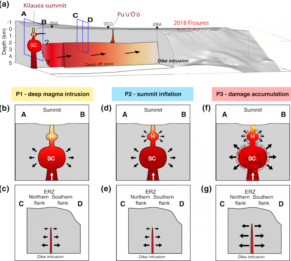
It's fascinating to expend seismology into the 4th dimension of time as a new monitoring means to probing the Earth structural variations. As the first attempt, we apply the ambient noise interferometry technique to the 2018 Kilauea volcano eruption to investigate how and when the pre-eruptive magmatic processes occurred in the reservoir-dike system. The spatiotemporal dv/v variations show significant precursory signals featuring three main stages of the magmatic intrusion processes: (1) deep magma intrusion, (2) summit inflation, and (3) accumulating damage of edifice. Our results highlight a long precursory phase to the Kilauea volcano eruption beginning from the December 2017 and shed light on detailed progression and interaction of the reservoir-dike magmatic system. (Feng et al., 2020). To follow up this direction, our group are now devoting to so-called environmental seismology and developing real-time dv/v monitoring systems in studying fault zones and landslides in Taiwan.
Full waveform inversion and modeling
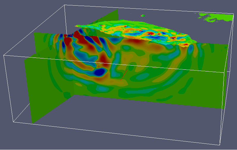
In addition to the strategy of incorporating multiple datasets as many as possible, utilizing the full information of seismic waveform becomes an appealing alternative recently. Benefited by the advances of numerical modeling techniques (e.g. SEM) and the application of adjoint theory in seismology. The full waveform tomography that is experimented successfully in south California (Chen et al., 2007; Tape et al., 2009) shows the potential for the new generation of tomography technique, in which the 3D off-path effects can also be considered more realistically. Current travel-time tomographic models of Taiwan region can simulate waveform up to 5-sec period (Huang et al., 2014). However, this achieved band has not been high enough for community applications (e.g. hazard mitigation), and more data (i.e. waveform information) and the 3D off-path effect have to be considered for higher frequency band. The high-density seismic network (station spacing ~5 km) and abundant earthquakes (~17,000/yr) in Taiwan is promising for the test of 3D full waveform tomography, but also very challenged by the great tectonic complexity in such small-scale region of Taiwan.
