跳至主要內容

研究

::: 首頁/研究 - 研究領域

研究領域

地震學

研究人員︰黃柏壽馬國鳳林正洪郭本垣李憲忠戚務正郁文哲黃信樺
研究技術人員︰梁文宗林慶仁林欽仁古進上

地震學的研究是利用地震與其他各式自然振動源(如海浪)所產生的波傳訊息來了解震源與地下傳播介質的物理特性與構造形貌,進而探究其與斷層、火山岩漿系統、造山運動、內核演化等從岩石圈到地球深部構造活動的關係,應用涵蓋的主題非常廣泛。

地球所近期主要的研究方向包括了(1)以數值模型探討大地震孕震與破裂的行為特性、(2)利用高精度波傳模擬反演斷層破裂過程、(3)以非傳統地震學方法進行火山與山崩活動的監測、(4)利用剪力波分離特性探討隱沒帶動力流場與造山帶模型、(5)使用地震陣列方法研究地震引起的地動旋轉特性、(6)對中大型地震進行強地動分析與預警、(7)利用地震層析成像解析隱沒板塊與火山岩漿庫的幾何形貌、(8)從海底震測剖面分析沉積構造歷史與甲烷水合物分布、以及(9)整合多重物理量觀測的地震前兆研究等。

地球所也致力在台灣與海外佈設與運行多個獨特的地震測站網如臺灣地區寬頻地震觀測網(BATS)、臺北盆地井下強震儀陣列、臺灣山區強震儀陣列、大屯火山地震觀測網,以及在東南亞與中亞的流動式地震陣列;通過合作與衛星通訊接收全球上千個地震站的即時波形數據。技術開發方面,地球所更與中山大學海下科技研究所以及國研院海洋中心自主開發台灣的寬頻海底地震儀;與德國LMU大學和新加坡南洋理工持續合作與跟進旋轉地震儀與次聲波儀器的開發與最新進展。結合多元的研究與觀測網,地球所的地震學研究旨在深入了解地球內部的各種構造系統;並對台灣以及東南亞地區的地震與地質災害做出實質的貢獻。

研究成果

Active Volcanism Revealed from a Seismicity Conduit in the Long-resting Tatun Volcano Group of Northern Taiwan
本所林正洪特聘研究員研究團隊分析從西元2014年到2017年間,大屯火山觀測站(TVO)在大屯火山群所設置的密集地震觀測網的地震資料,清楚發現在大油坑附近地底下,大約從海平面至2公里深度的極淺部地殼中,總共偵測到一千多個地震,幾乎均集中在一個高約2公里、直徑約500公尺的「火山通道」內 (下圖)。如此集中的地震分布產生的原因,主要是由於地底下岩漿或熱液,在高溫作用下產生的水蒸氣、二氧化碳、硫化物等氣體向上竄升所造成的地震。這是在大屯火山群首度發現的「火山通道」,不僅再度說明大屯火山群是個活火山,同時可以推估未來如果萬一大屯火山群再度噴發,這個「火山通道」很可能將成為岩漿的噴發點,但是我們也不能完全排除其他的可能的火山噴發地點。 詳細的研究成果請您參考已經發表在2020年度科學報導的論文(Pu et al., 2020)。
林正洪
瞭解更多
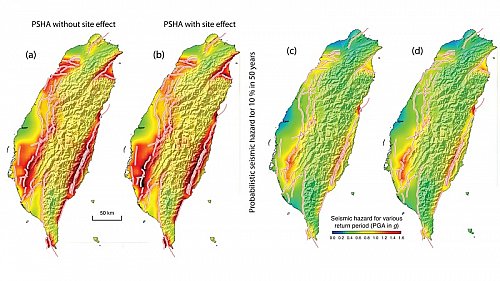
Crowdsourcing Platform Toward Seismic Disaster Reduction: The Taiwan Scientific Earthquake Reporting (TSER) System
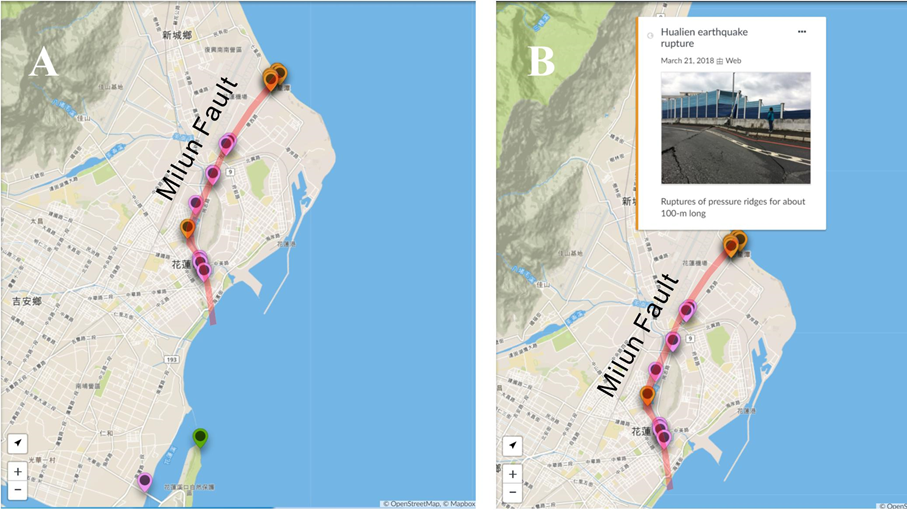
We initiated an earthquake reporting project in 2016 to collect field observations of ground damages caused by large earthquakes from trained volunteers and interested citizens. After a potentially damaging earthquake occurs in the Taiwan area, our system, the Taiwan scientific earthquake reporting system (TSER), would send a notice to the participants, who are encouraged to visit the epicentral area to survey and describe in as much detail as possible the variations of the ground damages using a Usahidi-based mapping platform. They may also upload relevant images in the field when the condition permitted (i.e., good mobile signal). This collective information will be shared with the public after a quick check by the on-duty scientists. Statistically, in Taiwan damaging inland earthquakes, e.g., magnitude greater than 6, occurred every 2–3 years. During the intermittent time, the platform serves to share educational materials such as pictures of geological structures and landscapes, which are beneficial to many of the volunteers, who are high school science teachers. This experimental, science-oriented crowdsourcing system was first tested during the February 6, 2018 Mw 6.4 offshore Hualien, Taiwan earthquake. We received 19 field reports in the first 3 days after the earthquake. Most of these reports provided surface damage details along the Milun fault, which also ruptured during the 1951 ML 7.1 Longitudinal Valley earthquake sequence. The crowdsourcing approach of TSER has proven to be effective in enhancing public awareness and the potential for scientific advancement in hazard mitigation.
梁文宗
瞭解更多
Evaluations of an ocean bottom electro-magnetometer and preliminary results offshore NE Taiwan
The first stage of field experiments involving the design and construction of a low-power consumption ocean bottom electro-magnetometer (OBEM) has been completed, which can be deployed for more than 180 d on the seafloor with a time drift of less than 0.95 ppm. To improve the performance of the OBEM, we rigorously evaluated each of its units, e.g., the data loggers, acoustic parts, internal wirings, and magnetic and electric sensors, to eliminate unwanted events such as unrecovered or incomplete data. The first offshore deployment of the OBEM together with ocean bottom seismographs (OBSs) was performed in NE Taiwan, where the water depth is approximately 1400 m. The total intensity of the magnetic field (TMF) measured by the OBEM varied in the range of 44 100–44 150 nT, which corresponded to the proton magnetometer measurements. The daily variations in the magnetic field were recorded using the two horizontal components of the OBEM magnetic sensor. We found that the inclinations and magnetic data of the OBEM varied with two observed earthquakes when compared to the OBS data. The potential fields of the OBEM were slightly, but not obviously, affected by the earthquakes.
林慶仁
瞭解更多
Deep-sea turbulence evolution observed by multiple closely spaced instruments
Turbulent mixing in the deep ocean is not well understood. The breaking of internal waves on sloped seafloor topography can generate deep-sea turbulence. However, it is difficult to measure turbulence comprehensively due to its multi-scale processes, in addition to flow–flow and flow–topography interactions. Dense, high-resolution spatiotemporal coverage of observations may help shed light on turbulence evolution. Here, we present turbulence observations from four broadband ocean bottom seismometers (OBSs) and a 200-m vertical thermistor string (T-string) in a footprint of 1 × 1 km to characterize turbulence induced by internal waves at a depth of 3000 m on a Pacific continental slope. Correlating the OBS-calculated time derivative of kinetic energy and the T-string-calculated turbulent kinetic energy dissipation rate, we propose that the OBS-detected signals were induced by near-seafloor turbulence. Strong disturbances were detected during a typhoon period, suggesting large-scale inertial waves breaking with upslope transport speeds of 0.2–0.5 m s−1. Disturbances were mostly excited on the downslope side of the array where the internal waves from the Pacific Ocean broke initially and the turbulence oscillated between < 1 km small-scale ridges. Such small-scale topography caused varying turbulence-induced signals due to localized waves breaking. Arrayed OBSs can provide complementary observations to characterize deep-sea turbulence.
戚務正
瞭解更多
Probabilistic seismic hazard assessment for Taiwan: TEM PSHA2020
The Taiwan Earthquake Model (TEM) published the first version of the Taiwan probabilistic seismic hazard assessment (named TEM PSHA2015) 5 years ago.
馬國鳳
瞭解更多
S Coda and Rayleigh Waves From a Decade of Repeating Earthquakes Reveal Discordant Temporal Velocity Changes Since the 2004 Sumatra Earthquake
Earthquake slip leads to stress relaxation in the crust, whereas healing of the damage induced by strong ground motion predominantly occurs in the near-surface. Temporal changes in the seismic velocity structure after large earthquakes can be driven by diverse mechanisms, such as aseismic slip or fault zone healing, but the timescales governing these processes are very similar, making them difficult to distinguish. We detect temporal velocity changes in the crust since the great 2004 Sumatra and 2005 Nias earthquakes using the high-frequency late-arriving scattered waves after the S phase and long-period Rayleigh waves of repeating earthquakes. We find that the temporal velocity changes in the scattered waves exhibit steady logarithmic recovery from 2005 to 2015, whereas the Rayleigh-wave velocity recovery was interrupted by several large earthquakes after late 2007. The difference between these two temporal trends in velocity change is the key to distinguishing between a damage/healing/re-damage cycle near the surface and slow deformation (e.g., afterslip, post-seismic relaxation) at depth. Rayleigh waves are highly sensitive to the near-surface damage and healing after the 2004/2005 events, and also the repeated damage induced by the 2007 and 2008 earthquakes. Steady velocity recovery of the scattered waves primarily corresponds to slow deformation at depth.
郁文哲
瞭解更多
Rayleigh-Love Discrepancy Highlights Temporal Changes in Near-Surface Radial Anisotropy After the 2004 Great Sumatra Earthquake
This study detects temporal changes in the wave speeds of long-period Rayleigh and Love waves after the 2004 Great Sumatra Earthquake, which were measured from repeating earthquakes. Seismic observations reveal that the Rayleigh-wave speed reduction is more than that of Love waves by a factor of six. Love waves are much more sensitive to the S-wave speed of the shallow crust than Rayleigh waves in isotropic media (i.e., the S-wave speed is the same in all directions). One would therefore anticipate considerable Love-wave speed reduction if the S-wave speed reduction results from the near surface after great earthquakes. However, the observations indicate the opposite. The result of waveform modeling suggests that these unexpected observations can be suitably explained by an increase in radial anisotropy as a result of increasing fluid-filled horizontal cracks after great earthquakes.
郁文哲
瞭解更多
Mantle wedge diapirs detected by a dense seismic array in Northern Taiwan
It is conventionally believed that magma generation beneath the volcanic arc is triggered by the infiltration of fluids or melts derived from the subducted slab. However, recently geochemical analyses argue the arc magma may be formed by mélange diapirs that are physically mixed by sediment, altered oceanic crust, fluids, and mantle above the subducted slab. Further numerical modeling predicts that the mantle wedge diapirs have significant seismic velocity anomalies, even though these have not been observed yet. Here we show that unambiguously later P-waves scattered from some obstacles in the mantle wedge are well recorded at a dense seismic array (Formosa Array) in northern Taiwan. It is the first detection of seismic scattering obstacles in the mantle wedge. Although the exact shape and size of the scattered obstacles are not well constrained by the arrival-times of the later P-waves, the first order approximation of several spheres with radius of ~ 1 km provides a plausible interpretation. Since these obstacles were located just beneath the magma reservoirs around depths between 60 and 95 km, we conclude they may be mantle wedge diapirs that are likely associated with magma generation beneath active volcanoes.
林正洪
瞭解更多
Deep crust analysis beneath northern Vietnam by using receiver functions: Implications for SE Asia continental extrusion
The shear-wave velocity structures of the crust and uppermost mantle of northern Vietnam were analyzed using the receiver function (RF) method at 25 broadband stations to investigate the regional crustal structure and its tectonic evolution. In this study, we presented a new crustal shear-wave velocity structure of northern Vietnam determined through RF analysis. Our results revealed significant variations in crustal thickness and deep crustal velocities across the study area. Along the Red River shear zone (RRSZ), the patterns of the crustal structure were distinct on both sides; they were simple and complex, respectively, in the blocks on northeast and southwest. A low-velocity zone (LVZ) was widely observed in the northwestern corner of the study area, and significant lateral variations in the thickness and strength of the crustal structure were observed from north to south. This LVZ was distributed as a thick and deep zone in the north and became thinner and shallower in the central region; the LVZ finally disappeared in the south. Two end members of the origin of the LVZ were proposed. The LVZ can be considered a weak crustal layer that escaped from the southeastern margin of the Tibetan Plateau, or it may have been formed from a paleo-subducted slab beneath it because of an onsite mantle heat source. The existence of this LVZ suggests that the movement of the RRSZ is possibly concentrated above the LVZ and that extension to the upper mantle is not necessary in the present stage. The above tectonic regime supports the possibility that the RRSZ is a strikeslip fault with a feature restricted in the crust.Full Article: https://doi.org/10.3319/Tao.2020.03.05.01 
黃柏壽
瞭解更多
Complex Triggering Supershear Rupture of the 2018 Mw 7.5 Palu, Indonesia, Earthquake Determined from Teleseismic Source Inversion
An MwMw 7.5 earthquake struck Palu in the northern coast of Sulawesi island, Indonesia, on 28 September 2018. Its focal mechanism was determined to be a left‐lateral strike‐slip fault, which is generally expected to not produce a tsunami. However, a large tsunami with runup heights of more than 6 m was observed along the coast of Palu city. Here, we show a complex triggering supershear source model as determined by teleseismic waveform inversion. Three asperities with different slip characteristics were found on the 120‐kilometer‐long rupture zone. Significant triggering rupture with a supershear speed was observed south of the epicenter, which was just beneath Palu city. This special rupture process can cause a strong directivity effect that produced anomalously large ground shaking with nonlinear effects in Palu area. The coseismic deformation determined from the inverted source model showed large horizontal displacements. These horizontal movements combined with complex bathymetry and topography could have pushed seawater to generate a tsunami even though the Palu earthquake was a strike‐slip event.
李憲忠
瞭解更多
Mantle flow entrained by the Hindu Kush continental subduction inferred from source-side seismic anisotropy
The intermediate-depth seismicity below the Hindu-Kush orogen is thought to mark the Indian-plate subduction with the bottom half of the slab currently breaking off. Unique features of this continental subduction are the near-vertical slab and the roughly stationary convergence boundary. How this subduction affects the mantle flow patterns remains to be understood. In this study we measured source-side shear wave splitting on the S waves from Hindu Kush intraslab events to sample the surrounding mantle. The observed fast polarization directions exhibit a circular pattern around the slab resembling that predicted for the toroidal flow driven by slab rollback. However, the rollback scenario is not favored because it hardly sustains in dynamic models without a considerable retreat of convergence boundary. We propose that the observed pattern is produced by the sub-vertical shear flow entrained by the steep descent of the slab and the ongoing breakoff. This scenario requires the existence of A-type or AG-type olivine fabrics with strong orthorhombic anisotropy in mid- to lower upper mantle, which is consistent with the global models of azimuthal and radial anisotropy. This interpretation circumvents the debate on the cause of trench-parallel anisotropy in some oceanic subduction zones where slab entrainment and rollback may coexist, and supports the notion that orthorhombic anisotropy of olivine may play an important role in shaping mantle anisotropy.
郭本垣
瞭解更多
Controls on seasonal variations of crustal seismic velocity in Taiwan using single-station cross-component analysis of ambient noise interferometry
Ambient noise interferometry is a powerful technique to continuously measuring crustal seismic velocity changes (dv/v) and studying crustal behaviors over time. However, the interpretation of such dv/v variations is not straightforward since multiple causes including internal (tectonic/magmatic) processes of the crust and external (environmental) factors could both affect dv/v simultaneously. To differentiate the interplay between the internal and external processes in dv/v variations is an essential step toward accurate crustal monitoring. In this study, we apply the single-station cross-component (SC) method to 15 selected stations from the Broadband Array in Taiwan for Seismology (BATS) to investigate the temporal evolution of crustal seismic velocities across Taiwan. We process the continuous BATS seismic recording from 1998 to 2019, construct the daily SC correlation functions, and compute dv/vvalues by the stretching technique in a frequency band of 0.1–0.9 Hz. We observe both strong annual dv/v variations and co-seismic velocity drops associated with regional moderate-to-large earthquakes. Systematic spectral and time-series analyses with the weather data suggest that the rainfall-induced pore-pressure change plays a predominant role in driving the dv/v seasonality, reflecting a diffusion process from meteoric water into shallow crust. The effects of other factors are relatively local and secondary. We also demonstrate how understanding and correcting rainfall effects could critically improve the resolution and accuracy of internal crustal damage related to earthquakes.
黃信樺
瞭解更多
Unveiling Tatun volcanic plumbing structure induced by post-collisional extension of Taiwan mountain belt
The Tatun Volcanic Group (TVG) is proximal to the metropolis of Taipei City (population of ca. 7 million) and has long been a major concern due to the potential risks from volcanic activity to the population and critical infrastructure. While the TVG has been previously considered a dormant or extinct volcano, recent evidence suggests a much younger age of the last eruption event (~ 6000 years) and possible existence of a magma reservoir beneath the TVG. However, the location, dimension, and detailed geometry of the magma reservoir and plumbing system remains largely unknown. To examine the TVG volcanic plumbing structure in detail, the local P-wave travel time data and the teleseismic waveform data from a new island-wide Formosa Array Project are combined for a 3D tomographic joint inversion. The new model reveals a magma reservoir with a notable P-wave velocity reduction of 19% (ca. ~ 19% melt fraction) at 8–20 km beneath eastern TVG and with possible northward extension to a shallower depth near where active submarine volcanoes that have been detected. Enhanced tomographic images also reveal sporadic magmatic intrusion/underplating in the lower crust of Husehshan Range and northern Taiwan. These findings suggest an active volcanic plumbing system induced by post-collisional extension associated with the collapse of the orogen.
黃信樺
瞭解更多
Seismogenic structure beneath the northern Longitudinal Valley revealed by the 2018-2021 Hualien earthquake sequences
This study uses the 3D crustal velocity model and the relocated earthquake hypocenters, including the 2018–2021 earthquake sequences, to re-assess the seismogenic structures at the northern Longitudinal Valley. Earthquake focal mechanisms and relocated hypocenters from earthquake clusters suggest a gentle west-dipping fault existing under the Longitudinal Valley and the Coastal Range. Earthquake clusters associated with this west-dipping fault indicate it develops along the base of high-velocity Central Range metamorphic rocks and is likely branched out from the previously recognized Central Range Fault (CRF). Both the 3D velocity model and the geometry of earthquake clusters suggest this structure truncates the Longitudinal Valley Fault north of 23.7° N, separating the northernmost LVF into the shallow and the deep segments. The shallow segment then plausibly evolves to be a transpressional fault system that mainly accommodates the left-lateral motions. This interpretation coincides with the geomorphological and geodetic observations showing that the northern LVF is dominated by the left-lateral faulting, instead of showing a significant reverse component as in the southern Longitudinal Valley. The limited fault width and geometry of the shallow LVF segment also imply its seismic potential is relatively limited, while the underling west-dipping fault and the deeper segment of the LVF are the major seismogenic structure. Such development of the major CRF-related west-dipping structure could accommodate the northwestward subduction of the Philippine Sea Plate and also likely reactivate part of the Offshore Eastern Taiwan Thrust Belt.
黃信樺
瞭解更多