地球物理學與地球動力學研究利用各式尖端的地球物理方法研究(一)固體地球內部複雜的構造及其分佈﹔(二)海底地震學﹔(三)板塊隱沒、行星地幔與岩石圈流動之機制及動力學過程﹔(四)地球深部礦物之物理與化學性質﹔(五)地球重力場與地磁場之演變及在自然災害與環境相關研究領域之應用等重要課題。
近年來重要的研究成果包括更清楚地重建歐亞板塊與菲律賓海板塊的三維隱沒幾何形貌、研究琉球隱沒帶之地幔流非均向性與動力機制、發現大屯火山與美國黃石火山下的深部岩漿庫、解析內核邊界速度構造與可能的半球邊界位置、自主研發寬頻海底地震儀並將其產業化與國際化、深度剖析全球動力學與地幔大尺度熱化學結構以及岩石圈剪切帶之形成機制、首次成功量測地幔與地核之熱傳導性質並結合數值模擬驗證其在地球熱演化過程之影響、精準觀測全球大地震對於地球自由震盪簡正模式頻譜之影響、發現由變質岩侵蝕而來的磁黃鐵礦可幫助追溯沉積物之來源以了解台灣及其它造山帶的剝蝕歷史。
We initiated an earthquake reporting project in 2016 to collect field observations of ground damages caused by large earthquakes from trained volunteers and interested citizens. After a potentially damaging earthquake occurs in the Taiwan area, our system, the Taiwan scientific earthquake reporting system (TSER), would send a notice to the participants, who are encouraged to visit the epicentral area to survey and describe in as much detail as possible the variations of the ground damages using a Usahidi-based mapping platform. They may also upload relevant images in the field when the condition permitted (i.e., good mobile signal). This collective information will be shared with the public after a quick check by the on-duty scientists. Statistically, in Taiwan damaging inland earthquakes, e.g., magnitude greater than 6, occurred every 2–3 years. During the intermittent time, the platform serves to share educational materials such as pictures of geological structures and landscapes, which are beneficial to many of the volunteers, who are high school science teachers. This experimental, science-oriented crowdsourcing system was first tested during the February 6, 2018 Mw 6.4 offshore Hualien, Taiwan earthquake. We received 19 field reports in the first 3 days after the earthquake. Most of these reports provided surface damage details along the Milun fault, which also ruptured during the 1951 ML 7.1 Longitudinal Valley earthquake sequence. The crowdsourcing approach of TSER has proven to be effective in enhancing public awareness and the potential for scientific advancement in hazard mitigation.
During its flyby of Pluto, in July 2015, the NASA's spacecraft New Horizon revealed that the surface of this dwarf planet is geologically very complex. Among the most interesting features is a nitrogen ice glacier, Sputnik Planitia, whose surface is split in a network of polygons of ~ 20-40 km in size, a structure which is characteristic of the dynamic topography induced by convection. Kenny Vilella (IES postdoc from 2015 to 2019) and Frédéric Deschamps (IES research fellow) investigated the dynamics of Sputnik Planitia using 3D-Cartesian simulations of thermal convection (Vilella and Deschamps, JGR Planets 2017). An important conclusion of their study is that the polygonal patterns observed at the surface of Pluto are inconsistent with bottom heated convection, as previously thought, but may instead result from volumetrically heated convection. According to this scenario, convection may be driven by successive phases of heating and cooling of the glacier triggered by long term variations of Pluto's orbital parameters. As Pluto's surface temperature increases Sputnik Planitia heats up by conduction and remains dynamically stable. As surface temperature starts decreasing, the glacier releases the heat it stored during the heating phase, and becomes unstable, i.e. it is cooling down following a convection process.
A dominant feature of the Earth’s mantle (the rocky layer that extends from depths of 50 to 2890 km) is the presence of large regions, called LLSVPs, where shear-wave velocity is reduced by a few percent compared to its horizontal average. The exact nature of these regions is still debated, but several hints point to a combination of thermal and compositional changes. Because seismic velocities alone cannot separate thermal and compositional contributions, other data are needed to infer the nature of LLSVPs. Seismic attenuation strongly depends on temperature and may thus be used as a proxy to infer temperature changes. Together with collaborators, Dr. Frédéric Deschamps (IES research fellow) performed studies to recover variations in shear-wave velocity (VS) and quality factor (Q) in the lowermost mantle, using inversions of seismic waveform data (Deschamps et al., EPSL, 2019). Doing so, they obtained radial models of VS and Q in the depth range 2000-2890 km at two different locations, beneath the Northern and Western Pacific. At the Western Pacific (WP) location, sampling the western tip of the Pacific LLSVP, both VS and Q are substantially lower than their mantle average. From the core-mantle boundary (2890 km) up to a depth of 2600 km, observed anomalies in VS and Q cannot be explained by thermal anomalies alone, even if changes in the stability field of the post-perovskite phase are accounted for. Compositional changes are also needed, and an excess in iron oxide by 3.5 to 4.5 % provides a good explanation to the observations.
Earth’s water cycle enables the incorporation of water (hydration) in mantle minerals that can influence the physical properties of the mantle. Lattice thermal conductivity of mantle minerals is critical for controlling the temperature profile and dynamics of the mantle and subducting slabs. However, the effect of hydration on lattice thermal conductivity remains poorly understood and has often been assumed to be negligible. Here we have precisely measured the lattice thermal conductivity of hydrous San Carlos olivine (Mg0.9Fe0.1)2SiO4 (Fo90) up to 15 gigapascals using an ultrafast optical pump−probe technique. The thermal conductivity of hydrous Fo90 with ∼7,000 wt ppm water is significantly suppressed at pressures above ∼5 gigapascals, and is approximately 2 times smaller than the nominally anhydrous Fo90 at mantle transition zone pressures, demonstrating the critical influence of hydration on the lattice thermal conductivity of olivine in this region. Modeling the thermal structure of a subducting slab with our results shows that the hydration-reduced thermal conductivity in hydrated oceanic crust further decreases the temperature at the cold, dry center of the subducting slab. Therefore, the olivine−wadsleyite transformation rate in the slab with hydrated oceanic crust is much slower than that with dry oceanic crust after the slab sinks into the transition zone, extending the metastable olivine to a greater depth. The hydration-reduced thermal conductivity could enable hydrous minerals to survive in deeper mantle and enhance water transportation to the transition zone.
The intermediate-depth seismicity below the Hindu-Kush orogen is thought to mark the Indian-plate subduction with the bottom half of the slab currently breaking off. Unique features of this continental subduction are the near-vertical slab and the roughly stationary convergence boundary. How this subduction affects the mantle flow patterns remains to be understood. In this study we measured source-side shear wave splitting on the S waves from Hindu Kush intraslab events to sample the surrounding mantle. The observed fast polarization directions exhibit a circular pattern around the slab resembling that predicted for the toroidal flow driven by slab rollback. However, the rollback scenario is not favored because it hardly sustains in dynamic models without a considerable retreat of convergence boundary. We propose that the observed pattern is produced by the sub-vertical shear flow entrained by the steep descent of the slab and the ongoing breakoff. This scenario requires the existence of A-type or AG-type olivine fabrics with strong orthorhombic anisotropy in mid- to lower upper mantle, which is consistent with the global models of azimuthal and radial anisotropy. This interpretation circumvents the debate on the cause of trench-parallel anisotropy in some oceanic subduction zones where slab entrainment and rollback may coexist, and supports the notion that orthorhombic anisotropy of olivine may play an important role in shaping mantle anisotropy.
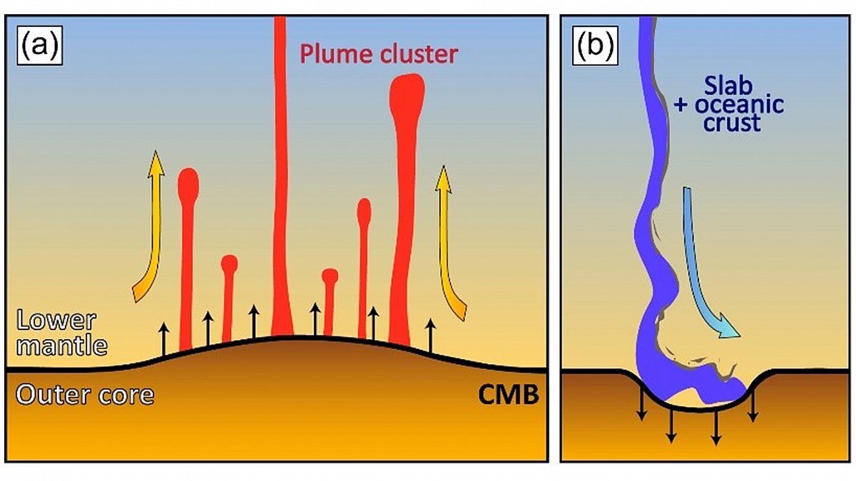
The Earth’s mantle is animated by large movement of convection transporting material from its bottom to its surface, and vice-versa. This flow is impacting the boundary between the core and the mantle, or core-mantle boundary (CMB), located at a depth of 2890 km. In particular, it deforms this boundary, creating some topography: thermal plumes stretch the CMB upward, inducing hills, while slabs arriving from the surface bump into it, triggering depressions. It is reasonable to think that details of CMB topography are controlled by the mode of convection animating the mantle, which depends itself on the mantle structure and properties. To assess whether CMB topography can indeed bring constraints on the deep mantle structure, Dr. Frédéric Deschamps (IES research fellow) and colleagues have calculated CMB dynamic topography induced by mantle flow for different models of mantle convection (Deschamps et al., GJI, 2018). Results show that in purely thermal models, plume clusters induce positive topography. By contrast, in thermo-chemical models with density contrast (ΔρC) around 100 kg/m3 or more, reservoirs of dense material induce depressions about 2 km deep in the CMB. In addition, the long-wavelength (spherical harmonic degrees up to l = 4) dynamic topography and seismic shear velocity anomalies are anti-correlated for purely thermal models, while they correlate for models with ΔρC ≥ 100 kg/m3. This potentially provides a test to infer the nature, thermal or thermo-chemical, of low shear-wave velocity provinces (LLVSP) observed by global tomographic images.
本所林正洪特聘研究員研究團隊分析從西元2014年到2017年間,大屯火山觀測站(TVO)在大屯火山群所設置的密集地震觀測網的地震資料,清楚發現在大油坑附近地底下,大約從海平面至2公里深度的極淺部地殼中,總共偵測到一千多個地震,幾乎均集中在一個高約2公里、直徑約500公尺的「火山通道」內 (下圖)。如此集中的地震分布產生的原因,主要是由於地底下岩漿或熱液,在高溫作用下產生的水蒸氣、二氧化碳、硫化物等氣體向上竄升所造成的地震。這是在大屯火山群首度發現的「火山通道」,不僅再度說明大屯火山群是個活火山,同時可以推估未來如果萬一大屯火山群再度噴發,這個「火山通道」很可能將成為岩漿的噴發點,但是我們也不能完全排除其他的可能的火山噴發地點。 詳細的研究成果請您參考已經發表在2020年度科學報導的論文(Pu et al., 2020)。
The first stage of field experiments involving the design and construction of a low-power consumption ocean bottom electro-magnetometer (OBEM) has been completed, which can be deployed for more than 180 d on the seafloor with a time drift of less than 0.95 ppm. To improve the performance of the OBEM, we rigorously evaluated each of its units, e.g., the data loggers, acoustic parts, internal wirings, and magnetic and electric sensors, to eliminate unwanted events such as unrecovered or incomplete data. The first offshore deployment of the OBEM together with ocean bottom seismographs (OBSs) was performed in NE Taiwan, where the water depth is approximately 1400 m. The total intensity of the magnetic field (TMF) measured by the OBEM varied in the range of 44 100–44 150 nT, which corresponded to the proton magnetometer measurements. The daily variations in the magnetic field were recorded using the two horizontal components of the OBEM magnetic sensor. We found that the inclinations and magnetic data of the OBEM varied with two observed earthquakes when compared to the OBS data. The potential fields of the OBEM were slightly, but not obviously, affected by the earthquakes.
The Tatun Volcanic Group (TVG) is proximal to the metropolis of Taipei City (population of ca. 7 million) and has long been a major concern due to the potential risks from volcanic activity to the population and critical infrastructure. While the TVG has been previously considered a dormant or extinct volcano, recent evidence suggests a much younger age of the last eruption event (~ 6000 years) and possible existence of a magma reservoir beneath the TVG. However, the location, dimension, and detailed geometry of the magma reservoir and plumbing system remains largely unknown. To examine the TVG volcanic plumbing structure in detail, the local P-wave travel time data and the teleseismic waveform data from a new island-wide Formosa Array Project are combined for a 3D tomographic joint inversion. The new model reveals a magma reservoir with a notable P-wave velocity reduction of 19% (ca. ~ 19% melt fraction) at 8–20 km beneath eastern TVG and with possible northward extension to a shallower depth near where active submarine volcanoes that have been detected. Enhanced tomographic images also reveal sporadic magmatic intrusion/underplating in the lower crust of Husehshan Range and northern Taiwan. These findings suggest an active volcanic plumbing system induced by post-collisional extension associated with the collapse of the orogen.
The subducting South China Sea crust at the northern Manila Trench has been categorized as the transitional crust, which is a rifted, thinned continental crust. We tested the consequence of the subduction of transitional crust with a numerical dynamic model. Our numerical model indicates that, with subducting transitional crust, normal fault earthquakes underneath the accretionary prism would occur deeper and probably with larger magnitude. Normal fault earthquakes near the trench outer rise are usually shallower than 30 km depth around the world. A notable exception is at the northern Manila Trench where normal fault earthquakes around 40 km depth are common, which can be explained by our model. Our result indicates that the stress on the northern segment of the Manila Trench is relaxed, which is less likely to generate great megathrust earthquakes.
Turbulent mixing in the deep ocean is not well understood. The breaking of internal waves on sloped seafloor topography can generate deep-sea turbulence. However, it is difficult to measure turbulence comprehensively due to its multi-scale processes, in addition to flow–flow and flow–topography interactions. Dense, high-resolution spatiotemporal coverage of observations may help shed light on turbulence evolution. Here, we present turbulence observations from four broadband ocean bottom seismometers (OBSs) and a 200-m vertical thermistor string (T-string) in a footprint of 1 × 1 km to characterize turbulence induced by internal waves at a depth of 3000 m on a Pacific continental slope. Correlating the OBS-calculated time derivative of kinetic energy and the T-string-calculated turbulent kinetic energy dissipation rate, we propose that the OBS-detected signals were induced by near-seafloor turbulence. Strong disturbances were detected during a typhoon period, suggesting large-scale inertial waves breaking with upslope transport speeds of 0.2–0.5 m s−1. Disturbances were mostly excited on the downslope side of the array where the internal waves from the Pacific Ocean broke initially and the turbulence oscillated between < 1 km small-scale ridges. Such small-scale topography caused varying turbulence-induced signals due to localized waves breaking. Arrayed OBSs can provide complementary observations to characterize deep-sea turbulence.
Earthquake slip leads to stress relaxation in the crust, whereas healing of the damage induced by strong ground motion predominantly occurs in the near surface. Temporal changes in the seismic velocity structure after large earthquakes can be driven by diverse mechanisms, such as aseismic slip or fault zone healing, but the timescales governing these processes are very similar, making them difficult to distinguish. We detect temporal velocity changes in the crust since the great 2004 Sumatra and 2005 Nias earthquakes using the high‐frequency late‐arriving scattered waves after the S phase and long‐period Rayleigh waves of repeating earthquakes. We find that the temporal velocity changes in the scattered waves exhibit steady logarithmic recovery from 2005 to 2015, whereas the Rayleigh wave velocity recovery was interrupted by several large earthquakes after late 2007. The difference between these two temporal trends in velocity change is the key to distinguishing between a damage/healing/redamage cycle near the surface and slow deformation (e.g., afterslip and postseismic relaxation) at depth. Rayleigh waves are highly sensitive to the near‐surface damage and healing after the 2004/2005 events and also the repeated damage induced by the 2007 and 2008 earthquakes. Steady velocity recovery of the scattered waves primarily corresponds to slow deformation at depth.
Earth’s core is composed of iron (Fe) alloyed with light elements, e.g., silicon (Si). Its thermal conductivity critically affects Earth’s thermal structure, evolution, and dynamics, as it controls the magnitude of thermal and compositional sources required to sustain a geodynamo over Earth’s history. Here we directly measured thermal conductivities of solid Fe and Fe–Si alloys up to 144 GPa and 3300 K. 15 at% Si alloyed in Fe substantially reduces its conductivity by about 2 folds at 132 GPa and 3000 K. An outer core with 15 at% Si would have a conductivity of about 20 W m−1 K−1, lower than pure Fe at similar pressure–temperature conditions. This suggests a lower minimum heat flow, around 3 TW, across the core–mantle boundary than previously expected, and thus less thermal energy needed to operate the geodynamo. Our results provide key constraints on inner core age that could be older than two billion-years.
It is conventionally believed that magma generation beneath the volcanic arc is triggered by the infiltration of fluids or melts derived from the subducted slab. However, recently geochemical analyses argue the arc magma may be formed by mélange diapirs that are physically mixed by sediment, altered oceanic crust, fluids, and mantle above the subducted slab. Further numerical modeling predicts that the mantle wedge diapirs have significant seismic velocity anomalies, even though these have not been observed yet. Here we show that unambiguously later P-waves scattered from some obstacles in the mantle wedge are well recorded at a dense seismic array (Formosa Array) in northern Taiwan. It is the first detection of seismic scattering obstacles in the mantle wedge. Although the exact shape and size of the scattered obstacles are not well constrained by the arrival-times of the later P-waves, the first order approximation of several spheres with radius of ~ 1 km provides a plausible interpretation. Since these obstacles were located just beneath the magma reservoirs around depths between 60 and 95 km, we conclude they may be mantle wedge diapirs that are likely associated with magma generation beneath active volcanoes.