跳至主要內容

研究

::: 首頁/研究 - 研究領域

研究領域

地質學與活動構造學

研究人員︰鍾孫霖李建成許雅儒詹瑜璋王國龍彭君能黃信樺林玉儂亞歷山卓
研究技術人員︰陳宏宇李皓揚

地球所的地質學與活動構造學研究領域包括不同時間與空間尺度之地殼演化過程與現今地殼變形與地表作用之研究。地球所在造山帶與造山作用研究包括,利用年代學和岩石地球化學彙整岩漿活動紀錄,及布設流動觀測寬頻地震站,以了解現今地下結構和震源特性,這些研究有助於了解造山帶在不同階段的演化歷程。主要研究地區涵蓋西藏—喜馬拉雅山和高加索—伊朗—安那托利亞高原,兩個世界上最重要的碰撞型造山帶,以及中亞造山帶與東南亞地區的增生型造山帶,還有年輕且典型的台灣造山帶,研究人員針對不同的造山帶進行對比研究,以期深入解析地球的地殼演化過程與造山作用。

在活動構造學研究方面,本所結合GPS連續觀測網的大量數據及井下應變觀測,探討地殼形變時空變化與地震活動之關聯性,並偵測可能之地殼形變地震前兆現象及地表作用。本所發展空載LiDAR數值地形,並應用此高解析度的地形研究地表地質、活動斷層、山崩機制及地表侵蝕作用等課題,未來更將進一步納入最新發展之InSAR技術應於地表作用之研究。此外,地球所也在花東縱谷陸續展開一系列地震與大地測量等研究工作,包括GPS及水準測量、池上斷層監測及數值模擬,以期掌握地表活斷層帶的破裂位置、變形範圍及速率,對地下斷層力學性質有所認知。本所在地質學與活動構造學領域之研究成果可為自然災害之防減災工作提供更具體的科學基礎。

研究成果

The 2020 Hpakant Jade Mine Disaster, Myanmar: A multi-sensor investigation for slope failure
A quarry failure along the slopes of the Wai Khar open-pit jade mine in Hpakant, Myanmar has led to the deaths of at least 172 jade miners on 2 July 2020. This paper conducts a systematic investigation of the incident by integrating data from multiple sensors, including high-resolution optical imagery, Sentinel-1 synthetic aperture radar (SAR) images, unmanned aerial system (UAS) footage, SRTM and ALOS digital elevation models (DEMs), soil moisture product from multi-spectral Landsat-8 satellite and precipitation records from the Climate Hazards Group InfraRed Precipitation with Station data (CHIRPS). Optical imagery, UAS footage and DEMs allow us to build a comprehensive mapping of tailing areas and quarry scarps from 2010 and reconstruct the 2D pit geometry prior to failure. Deformation signals from multi-temporal SAR interferometry (MTInSAR), soil moisture variations and precipitation trends further allow us to identify possible failure causes. To evaluate the quality of deformation obtained from different distributed-scatterer phase estimators, we develop an empirical mapping function based on areal fraction values to facilitate the comparison of temporal coherence values that are differently formulated in each phase estimator. The comparison shows that phase linking algorithm outperforms the small baseline subset method in terms of signal recovery and phase reliability. Our investigation points out that the mining site is under aggressive mining cycles that are exacerbated by frequent, uncontrolled landslides. Seepage failure, which involves the expulsion of water from rapidly compacting tailings, may be a critical factor in the 2020 incident. Instead of extreme weather, the failure had occurred under normal to drier conditions. This means that the sliding planes were already in a critical state, which is evident from the accelerated deformation around the collapse area since the beginning of 2020. Based on these findings, we provide recommendations to improve mining site regulations and management practices for safer open-pit mining in Myanmar and probably in similar contexts outside Myanmar.
林玉儂
瞭解更多
Unveiling Tatun volcanic plumbing structure induced by post-collisional extension of Taiwan mountain belt
The Tatun Volcanic Group (TVG) is proximal to the metropolis of Taipei City (population of ca. 7 million) and has long been a major concern due to the potential risks from volcanic activity to the population and critical infrastructure. While the TVG has been previously considered a dormant or extinct volcano, recent evidence suggests a much younger age of the last eruption event (~ 6000 years) and possible existence of a magma reservoir beneath the TVG. However, the location, dimension, and detailed geometry of the magma reservoir and plumbing system remains largely unknown. To examine the TVG volcanic plumbing structure in detail, the local P-wave travel time data and the teleseismic waveform data from a new island-wide Formosa Array Project are combined for a 3D tomographic joint inversion. The new model reveals a magma reservoir with a notable P-wave velocity reduction of 19% (ca. ~ 19% melt fraction) at 8–20 km beneath eastern TVG and with possible northward extension to a shallower depth near where active submarine volcanoes that have been detected. Enhanced tomographic images also reveal sporadic magmatic intrusion/underplating in the lower crust of Husehshan Range and northern Taiwan. These findings suggest an active volcanic plumbing system induced by post-collisional extension associated with the collapse of the orogen.
黃信樺
瞭解更多
Tracing Argoland in eastern Tethys and implications for India-Asia convergence
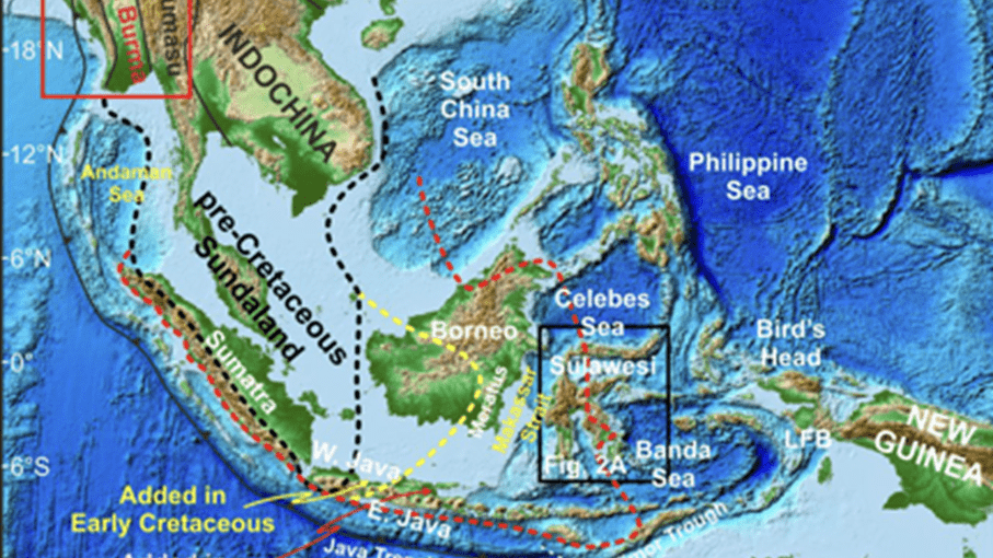
Incremental accretion of continental fragments from East Gondwana to Eurasia resulted in the growth of Asia and rise of the Tibetan Plateau, yet its detailed evolution remains uncertain. Argoland, a continental fragment that rifted from NW Australia during the Late Jurassic, played a key role in the initial opening of the Indian Ocean and the evolution of eastern Tethys. However, its present identity remains elusive, with East Java-West Sulawesi currently assumed to be the most likely option. To constrain the missing Argoland and its role in India-Asia convergence, we report new detrital zircon data from Sulawesi, Indonesia, and West Burma, Myanmar, and synthesize literature results from relevant regions in Southeast Asia, which (>15,000) reveal age profiles of West Sulawesi, the central Sulawesi metamorphic belt, and southeast Borneo comparable to that of Bird's Head, New Guinea, whereas age patterns of West Burma and East/West Java are similar to those of NW Australia. Notably, the most dominant age populations in NW Australia are rarely detected in Sulawesi and Borneo. These observations, combined with previous geological records and recent paleomagnetic data, suggest that West Burma is the mysterious Argoland, opposing the currently favored East Java-West Sulawesi model, with East Java and West Sulawesi probably having originated from NW Australia and Bird's Head, respectively. We estimate an average northward motion of ∼6–8 cm/yr for West Burma, which split from NW Australia to approach the equator during ca. 155–95 Ma, shedding new light on the reconstruction and breakup of northern East Gondwana, progressive building of Southeast Asia, and India-Asia convergence.
鍾孫霖
瞭解更多
Tracking Slow Landslide Movements with Optimized MTInSAR Workflow (2023)
This study focuses on detecting and monitoring slow-moving landslides in Taiwan using a sophisticated radar technique. Identifying over 2500 pre-existing landslides is crucial for assessing their activity, especially before typhoon seasons. The proposed method, "multi-snap2stamps," effectively analyzes nine slow-moving landslides, revealing seasonal patterns in two sites and accelerated movement in one. The study showcases the potential of the method for large-scale landslide detection and monitoring.
詹瑜璋
瞭解更多
Mid-Miocene volcanic migration in the westernmost Sunda arc induced by India-Eurasia collision
The migration of arc magmatism that is a fundamental aspect of plate tectonics may reflect the complex interaction between subduction zone processes and regional tectonics. Here we report new observations on volcanic migration from northwestern Sumatra, in the westernmost Sunda arc, characterized by an oblique convergent boundary between the Indo-Australian and Eurasian plates. Our study indicates that in northwestern Sumatra, volcanism ceased at 15–10 Ma on the southern coast and reignited to form a suite of active volcanoes that erupt exclusively to the north of the trench-parallel Sumatran fault. Younger volcanic rocks from the north are markedly more enriched in K2O and other highly incompatible elements, delineating
a geochemical variation over space and time similar to that in Java and reflecting an increase in the Benioff zone depth. We relate this mid-Miocene volcanic migration in northwestern Sumatra to the far-field effect of propagating extrusion tectonics driven by the India-Eurasia collision. The extrusion caused regional deformation southward through Myanmar to northwestern Sumatra and thus transformed the oblique subduction into a dextral motion–governed plate boundary. This tectonic transformation, associated with opening of the Andaman Sea, is suggested to be responsible for the volcanic migration in northwestern Sumatra.
鍾孫霖
瞭解更多
利用Tomo-PSInSAR技術進行都會區大規模建築物健康監測
建築結構健康監測(Structural Health Monitoring, SHM)對於老舊建築而言至關重要,特別是在地震活動頻繁的地區。然而,監測成本對多數私人建築擁有者而言常常難以負擔。本研究探討在都市規劃情境下,利用層析持續散射體干涉式合成孔徑雷達(Tomographic Persistent-Scatterer Interferometric Synthetic Aperture Radar, Tomo-PSInSAR)進行大規模結構健康監測的可行性。透過於台北盆地拍攝的 TerraSAR-X/TanDEM-X 衛星資料,在應用Tomo-PSInSAR技術取得建築物上反射點的變形速度後,我們建立一套用於評估建築物沉陷與傾斜速率的分析流程。分析結果顯示,盆地中有 11.6% 的建築輪廓多邊形具備 SHM 分析的條件,其中有 10.8% 顯示出異常變形現象。建築物的最大沉陷與傾斜速率分別達到 −14 毫米/年與 1/760 年⁻¹。
林玉儂
瞭解更多
Tracking the magmatic response to subduction initiation in the forearc mantle wedge: Insights from peridotite geochemistry of the Guleman and Kızıldağ ophiolites, Southeastern Turkey
The initiation of subduction is associated with sequential magmatic responses that lead to the formation of the forearc lithosphere, yet the detailed characteristics of these magmatic activities are not well constrained. Here we use mineral chemistries and bulk-rock trace-element contents of highly-depleted harzburgites from the Guleman and Kızıldağ ophiolites in Southeast Turkey to examine mantle wedge melting dynamics during subduction initiation. We focus on how different components from the subducting slabs potentially contribute to various stages of magmatism throughout the process. Mineral and bulk-rock compositions of these harzburgites are significantly different from those of abyssal peridotites, suggesting that our harzburgites cannot be explained as residues of anhydrous adiabatic melting and melt-rock interaction at mid-ocean ridges alone. This implies that the petrogenesis of SE Turkey harzburgites involves additional processes and components. Harzburgites with the most depleted heavy-rare earth element (HREE) contents are the ones with the highest abundance of strongly incompatible elements, which can be explained by open-system processes where the peridotites in the mantle wedge experienced melting and infiltration of enriched components simultaneously. Open-system dynamic melting models with continuous flux of sediment-derived melts can account for the observed correlation, but are numerically too low compared to the measured values. Based on the observed fractionation between Zr, Hf, and elements with similar incompatibility (middle REEs), we hypothesized the involvement of amphibolite-derived melt and modeled its numerical trace-element contents. Binary mixing between this hypothetical melt and residues of the former open-system model can coherently account for the majority of the obtained trace-element data. This indicates that magmatic events during subduction initiation likely involve multiple components and occur in multiple stages, and that melt-mantle interaction plays a significant role in oceanic forearc lithosphere formation. Based on our model, we suggest the high (Zr/MREE)N signatures in some boninites and depleted harzburgites found in modern forearcs and ophiolites could be inherited from amphibolite-derived melts. Moreover, the existence of slab melts agrees with current constraints on the reconstructed geothermal gradients during subduction initiation based on the petrology and geochemistry of metamorphic soles.
王國龍
瞭解更多
Seismogenic structure beneath the northern Longitudinal Valley revealed by the 2018-2021 Hualien earthquake sequences
This study uses the 3D crustal velocity model and the relocated earthquake hypocenters, including the 2018–2021 earthquake sequences, to re-assess the seismogenic structures at the northern Longitudinal Valley. Earthquake focal mechanisms and relocated hypocenters from earthquake clusters suggest a gentle west-dipping fault existing under the Longitudinal Valley and the Coastal Range. Earthquake clusters associated with this west-dipping fault indicate it develops along the base of high-velocity Central Range metamorphic rocks and is likely branched out from the previously recognized Central Range Fault (CRF). Both the 3D velocity model and the geometry of earthquake clusters suggest this structure truncates the Longitudinal Valley Fault north of 23.7° N, separating the northernmost LVF into the shallow and the deep segments. The shallow segment then plausibly evolves to be a transpressional fault system that mainly accommodates the left-lateral motions. This interpretation coincides with the geomorphological and geodetic observations showing that the northern LVF is dominated by the left-lateral faulting, instead of showing a significant reverse component as in the southern Longitudinal Valley. The limited fault width and geometry of the shallow LVF segment also imply its seismic potential is relatively limited, while the underling west-dipping fault and the deeper segment of the LVF are the major seismogenic structure. Such development of the major CRF-related west-dipping structure could accommodate the northwestward subduction of the Philippine Sea Plate and also likely reactivate part of the Offshore Eastern Taiwan Thrust Belt.
黃信樺
瞭解更多
Tatun Volcanic System: Thermal Patterns and Earthquake Correlation (2023)
Satellite-detected land surface temperature (LST) and seismic records are used to study the volcanic activity of Tatun Volcanic Group. Analyzing four decades of LST and three decades of earthquake magnitude data reveals a correlation between LST trends and energy released from volcanic earthquakes, validating the connection between surface temperatures and volcanic activity.
詹瑜璋
瞭解更多
Diachronous initiation of post-collisional magmatism in the Arabia-Eurasia collision zone
The continental collision between Arabia and Eurasia which gave rise to the Caucasus-Iran-Anatolia (CIA) volcanic province provides a unique opportunity for understanding collisional zone magmatism. This study reports a comprehensive dataset of ages and geochemical compositions of volcanic rocks formed during the initial phase of post-collisional magmatism in the CIA province. The age data indicate a diachronous onset of volcanism that began ~17 Ma in SE Anatolia, and propagated northward from ~11 to 9 Ma toward NE Anatolia and NW Iran. The rocks are characteristically bimodal, with dominantly basic (SiO2 = 48–52 wt%) and silicic (SiO2 = 58–71 wt%) components that feature significant isotopic variations (εNd = +6 to −5), suggesting two principal magma sources: (1) a juvenile mantle-derived component, and (2) an older continental crust component. We therefore attribute the volcanic initiation to a migrating post-collisional extension regime caused by the successive breakoff of subducted Neo-Tethyan slabs. Subsequent volcanism that began from ~6.5 Ma resulted in a wide spectrum of calc-alkaline and alkaline rocks, with mafic to felsic lithologies in the entire province. From ~2 Ma, volcanism ceased in the western CIA province, and started propagating eastward and southeastward to SE Iran, following the Urumieh-Dokhtar magmatic belt, consistent with the notion of an oblique continental collision between Arabia and Eurasia.
鍾孫霖
瞭解更多
Surface traces and related deformation structures of the southern Sanyi Fault, Taiwan, as deduced from field mapping, electrical-resistivity tomography, and shallow drilling
The southern Sanyi Fault extends across a highly urbanized area in central-west Taiwan. It is within 1–2 km from and generally parallels the northern Chelungpu Fault, which last ruptured in 1999 (Mw = 7.6 Chi-Chi Earthquake) and caused about 2400 fatalities. Several questions thus arise: is the Sanyi Fault likewise active? what is its geometry and extent? and should it be zoned or otherwise designated to mitigate risk through restrictions on development or engineering design? We address these questions by mapping river-exposed outcrops, by interpreting nine, near-surface geophysical surveys (electrical resistivity tomography [ERT]), and by compiling and assessing existing shallow borehole data. Outcrops in the Dajia River show that the Sanyi Fault is mainly a low-angle thrust that juxtaposes poorly lithified sandstone over alluvial gravels. Fault branches are common both in the hanging wall and footwall. To the south, the fault is not marked by a break in topography and its trace has not been clearly mapped within the alluvial plain, in part motivating the current effort. Here the ERT surveys identify the hanging-wall sandstone by a relatively low resistivity of <100 Ωm, whereas the footwall conglomerates and alluvial gravels generally exceed ~300 Ωm and ~ 100 Ωm, respectively. Borehole data likewise constrain the extent and character of the Sanyi Fault, which we identify as extending across the eastern part of Fengyuan, a city with a population now exceeding 160,000. The fault system is clearly imaged in two of five surveyed sites, and we integrate these data with drilling data to map the Sanyi fault surface trace as a ~ 400 m wide zone in the city of Fengyuan. Compiling previously documented paleoseismic data at one site, the Sanyi Fault system likely slipped in the thousand-year range throughout the Holocene. The Sanyi Fault is therefore ‘active’ and warrants zoning or other forms of mitigation to minimize potential, seismically induced loss of life and property.
李建成
瞭解更多
Variable vertical movements and their deformation behaviors at convergent plate suture: 14-year-long (2004-2018) repeated measurements of precise leveling around middle Longitudinal Valley in eastern Taiwan
To better characterize the vertical movements and the deformation behaviors across the plate suture of an arc-continent collision, we conducted annual repeated measurements on two precise leveling routes in a length of 34 and 37 km, respectively, across the middle part of the Longitudinal Valley in eastern Taiwan in 2004–2018. The 14-year-long results showed that the Longitudinal Valley fault (LVF) dominates the surface deformation: a) the middle LVF (Juisui fault) exhibited partially locked in the upper few kilometers, with a cumulative uplift rate of 9–10 mm/yr in a distance of 4 km; b) the southern LVF (Chihshang fault) showed a creeping behavior with a vertical rate of 24–27 mm/yr. In addition, we are able to characterize other features, including 1) tilting upward to the west in the eastern Central Range, suggesting activity on the west-dipping Central Range fault; 2) the hanging wall of the LVF showed tilting downward behavior to the east; 3) the Chimei fault, a suspected active fault, revealed active slip on the sub-vertical fault plane, that caused a vertical rate of 8–9 mm/yr. Putting the results under global ITRF system, the whole Juisui route was moving downward, supporting the notion that NNW subduction of the Philippine Sea plate starts around the latitude of the middle of the Longitudinal Valley. Finally, the co-seismic vertical deformation of the 2013 ML6.4 Juisui earthquake was characterized by tilting upward to the west, consistent with stick–slip on the deeper part of a west-dipping interface of the forearc basement.
李建成
瞭解更多
Magnesium isotopic systematics of the Makran arc magmas, Iran: Implications for crust-mantle Mg isotopic balance
Continental crust loses Mg by lower crustal foundering and chemical weathering to become its intermediate-silicic composition. Both processes should preferentially retain heavy Mg isotopes in the crust, yet the estimated Mg isotopic ratio for the bulk continental crust is indistinguishable from that for unmodified mantle. This can be elucidated by two notions that are not mutually exclusive: (i) the basaltic parent to the crust has Mg isotopes lighter than the mantle and has since become mantle-like as a result of Mg loss by igneous and weathering fractionation, and (ii) heavy Mg isotopes in the continental crust are constantly balanced by a hidden input of light Mg isotopes. Arc magmas are arguably building blocks of the continental crust and their Mg isotopic signature could be used to place limits on the above views. Here, we conducted a Mg isotopic study of the Makran arc, a rare continental arc in Iran within the Alpine-Himalayan orogenic belt. The measured Mg isotopic ratios for most mafic and intermediate samples are mantle-like with δ26Mg values ranging from −0.32‰ to −0.20‰. After excluding dubious samples affected by alteration, the silicic samples span a broad range of isotopic ratios with δ26Mg values ranging from −0.32‰ to +0.32‰, beyond that of unmodified mantle (δ26Mg = −0.25 ± 0.04‰). The isotopic data form a trend from mantle-like δ26Mg at relatively high MgO towards elevated δ26Mg at low MgO, requiring the isotopic variability be related to differentiation in an open system involving assimilation of high-δ26Mg crustal rocks. Our results are generally consistent with Mg isotopic data compiled for global arcs where magmas have Mg isotopic ratios ranging from mantle-like to ∼0.7 per mil above the mantle range, and compositions substantially below that range are rare. Thus, heavy Mg isotopes in the continents predicted by igneous and weathering fractionation might have been compensated by a hidden input of light Mg isotopes, which is presumably in the form of carbonates, leading to a bulk crustal Mg isotopic composition that is mantle-like.
彭君能
瞭解更多
Synchronized and asynchronous modulation of seismicity by hydrological loading: A case study in Taiwan
Delineation of physical factors that contribute to earthquake triggering is a challenging issue in seismology. We analyze hydrological modulation of seismicity in Taiwan using groundwater level data and GNSS time series. In western Taiwan, the seismicity rate reaches peak levels in February to April and drops to its lowest values in July to September, exhibiting a direct correlation with annual water unloading. The elastic hydrological load cycle may be the primary driving mechanism for the observed synchronized modulation of earthquakes, as also evidenced by deep earthquakes in eastern Taiwan. However, shallow earthquakes in eastern Taiwan (<18 km) are anticorrelated with water unloading, which is not well explained by either hydrological loading, fluid transport, or pore pressure changes and suggests other time-dependent processes. The moderate correlation between stacked monthly trends of large historic earthquakes and present-day seismicity implies a modestly higher seismic hazard during the time of low annual hydrological loading.
許雅儒
瞭解更多
Evaluation of single-frequency receivers for studying crustal deformation at the longitudinal Valley fault, eastern Taiwan
Applications of low-cost single-frequency continuous GPS receivers for monitoring volcano and landslide activities as well as to complement dual-frequency receivers have been demonstrated to produce stable and accurate positioning. In studies of crustal deformation, the relative distance between monitoring stations may vary from several kilometers to tens of kilometers, hence the differential single-frequency observations cannot model the ionospheric delay or other distance dependent errors. The 55 low-cost single-frequency continuous stations have been deployed together with 52 continuous dual-frequency stations in southeastern Taiwan since 2008. All of the single-frequency stations have applied corrections using dual-frequency stations to eliminate the distance dependent errors. Comparing velocity estimates from 8 co-located, the differences in horizontal and vertical components are less than 3 mm/yr and 6 mm/yr, respectively. Our study shows that the combination of single- and dual-frequency GPS data can provide robust results to study the fault slip behavior on the Longitudinal Valley fault.
陳宏宇
瞭解更多
Inherited State of Stress as a Key Factor Controlling Slip and Slip Mode: Inference From the Study of a Slow Slip Event in the Longitudinal Valley, Taiwan
Tectonic faults display a large range of slip behaviors, ranging from fast slip (earthquakes) to episodic or continuous aseismic slow slip. Episodic aseismic slip events (typically called 'slow slip events') are now widely observed in active regions and play an important role in stress redistribution in the Earth's crust. The Longitudinal Valley Fault is the most active fault in Taiwan, hosting large to destructive earthquakes. However, very little is known about the presence and the role of slow slip events on the fault deformation. We document a 13‐day long slow slip event with a magnitude of 5.45, which represe'nts the largest event detected on the fault to date. We demonstrate that the slow event was likely encouraged by stress accumulation due to the 2003 Chengkung earthquake. Monitoring and characterizing the sources of aseismic slip is fundamental to identify areas with high seismic hazard on the fault and to shed some light on the interactions between seismic and aseismic processes.
亞歷山卓
瞭解更多
Coulomb stress changes triggering surface pop-up during the 2016 Mw 6.4 Meinong earthquake with implications for earthquake-induced mud diapiring in SW Taiwan
We investigated the 2016 Meinong earthquake (Mw 6.4) in southwestern Taiwan, which caused surface pop-up in an area of 10x15 km2 with maximum uplift of 12 cm, where lies an array of mud volcanoes and possible underlying mud diapir. We calculated 3D strain tensor in a 3D mesh with 5x5x2 km grids in the epicentral area induced by the Coulomb stress change due to coseismic fault slip. We obtained substantial contraction strain (10−5–10−6) that occurred in a lobe showing “squeezing” at the depth of 5–14 km below the surface pop-up area. Dilatation strain (10−5–10−6) occurred at shallow level (0–3 km) with a radial pattern around the surface pop-up area. Combining with local geology, which is composed of Mio-Pliocene ~5-km-thick mudstone in a fold-thrust belt, we interpret that the 2016 Meinong coseismic surface pop-up was closely related to mud diapirs/volcanoes, which were likely reactivated by sudden increase of fluid pore-pressure in the basal reservoir (at 5–6 km depth) and dilatation in the shallow level. We also explored the potential effects of the Coulomb stress transfer on nearby receiver faults – including three arrays of mud diapir, the regional decollement, a suspected backthrust and one thrust close to the pop-up area. Our results show that the Coulomb stress transfer a) favors NNE-trending mud diapirs in the coseismic pop-up area, with a combination of clamping stress changes at 5–6 km depth and unclamping stress changes at 0–4 km depth, and b) it does not favor triggered thrust slip on the regional thrusts.
李建成
瞭解更多
不同波段的雷達波,對於山崩偵測的會是效力如何?
本研究試圖回答以下問題:合成孔徑雷達中不同的資料性質如何影響對山崩偵測的效力?我們透過2018年北海道地震引起的大範圍山崩,以及2017年台灣荖濃溪上游支流布唐布納斯溪因豪雨造成的山崩事件,來完整分析波長、空間解析度、偏極組合以及視角幾何等因素將會如何影響合成孔徑雷達資料對於山崩偵測的能力。
林玉儂
瞭解更多
Assessing Decadal Sediment Erosion Rates: Insights from Improved DEMs of Differencing
This study examines sediment erosion in Taiwan's Zhoukou River Basin over the past 30 years, focusing on the impact of extreme rainfall. Traditional methods measure erosion over different time scales, but we used a unique approach for decade-long calculations with global and regional digital elevation models (DEMs). Our new method, applying Fourier analysis, reduces vertical bias in DEMs. Spectral analysis helps correct vertical offsets. Erosion rates calculated through DEMs of Difference (DoD) show a significant drop in sediment export from 1990-2010 to 2011-2020 due to reduced extreme rainfall. The denudation rate decreased from 14.19 mm/yr to 10.46 mm/yr in the Zhoukou River Basin. Our method effectively estimates sediment transport rates using underutilized DEMs.
詹瑜璋
瞭解更多
2020年緬甸帕干玉礦礦災是怎麼發生的?
2020年七月初在緬甸北方克欽省發生嚴重的礦災,死亡人數超過170人,為緬甸過去十年來礦災死傷最慘重的一次。我們藉由多重衛星遙感資料的分析指出,異常氣候並非致災的主因,反而是因為露天開採的礦區設計失當,造成其側壁存在長期不穩定性。因此除了建議各國監管單位修改相關規範之外,更應該透過本研究提出的多重衛星感測資料分析方法,對礦坑進行長期監測,以避免憾事持續發生。
林玉儂
瞭解更多